ZCZC MIATWOAT ALL
TTAA00 KNHC DDHHMM
Special Tropical Weather Outlook
NWS National Hurricane Center Miami FL
1125 AM EDT Fri Sep 11 2020
For the North Atlantic...Caribbean Sea and the Gulf of Mexico:
Special Tropical Weather Outlook issued to update the discussion
and development potential for the area of disturbed weather near
the Bahamas.
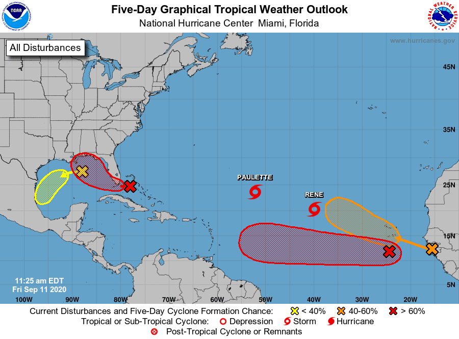
The National Hurricane Center is issuing advisories on Tropical
Storm Paulette, located over the central tropical Atlantic, and on
Tropical Storm Rene, located over the eastern tropical Atlantic.
1. Updated: Shower and thunderstorm activity located over the
northwestern and central Bahamas and the adjacent waters continues
to shows signs of organization. In addition, surface observations
indicate that pressures have fallen over the area since yesterday
and, along with wind data, suggest that a broad area of low pressure
could be forming between the northwestern Bahamas and South Florida.
This system is forecast to move westward at about 10 mph, crossing
the Bahamas and Florida today and tonight and moving into the
eastern Gulf of Mexico on Saturday. The disturbance could become a
tropical depression while it is near South Florida tonight, but it
is more likely to become a tropical depression while it moves slowly
west-northwestward over the eastern Gulf of Mexico this weekend and
early next week. Regardless of development, this system is expected
to produce locally heavy rainfall over portions of the Bahamas,
South Florida, and the Florida Keys during the next couple of days,
and interests there, as well as along the northern and eastern Gulf
coast, should monitor its progress.
* Formation chance through 48 hours...medium...60 percent.
* Formation chance through 5 days...high...70 percent.
2. Another trough of low pressure is located over the north-central
Gulf of Mexico. Although the associated shower and thunderstorm
activity is currently minimal, some slow development of this system
is possible while it moves westward and then southwestward over the
northern and western Gulf of Mexico through early next week.
* Formation chance through 48 hours...low...10 percent.
* Formation chance through 5 days...low...30 percent.
3. A tropical wave is located a few hundred miles south of the Cabo
Verde Islands and is producing a large area of disorganized showers
and thunderstorms. Development of this system is forecast, and a
tropical depression is expected to form within the next few days
while the system moves generally westward at 15 to 20 mph across
the eastern and central tropical Atlantic.
* Formation chance through 48 hours...high...70 percent.
* Formation chance through 5 days...high...90 percent.
4. Another large area of disturbed weather associated with a tropical
wave is beginning to move off the west coast of Africa.
Environmental conditions appear conducive for development
during the next few days, and a tropical depression could form
over the far eastern tropical Atlantic early next week while the
system moves slowly westward. Upper-level winds could become less
conducive for development by Monday or Tuesday.
* Formation chance through 48 hours...low...10 percent.
* Formation chance through 5 days...medium...40 percent.
Forecaster Berg