Glossary of NHC Terms
See also: NWS Glossary
Jump to: a - b - c - d - e - f -
g - h - i - j - k - l - m - n - o -
p - q - r - s - t - u - v - w - x - y - z
- Advisory:
- Official information issued by tropical cyclone warning centers describing all tropical cyclone watches and warnings in effect along with details concerning tropical cyclone locations, intensity and movement, and precautions that should be taken. Advisories are also issued to describe: (a) tropical cyclones prior to issuance of watches and warnings and (b) subtropical cyclones.
- Best Track:
- A subjectively-smoothed representation of a tropical cyclone's location, intensity, type, and size over its lifetime. The best track contains the cyclone's latitude, longitude, maximum sustained surface winds, minimum sea-level pressure, stage (e.g., tropical, extratropical, remnant low, etc.), and size (e.g., radius of maximum winds, hurricane-force winds, 50-kt winds, and tropical storm-force winds) at 6-hourly intervals and at landfall for tropical storms and hurricanes. These best track attributes, based on a post-storm assessment of all available data, may differ from values contained in system advisories. The best track locations also generally will not reflect the erratic motion implied by connecting individual center fix positions.
- Center:
- Generally speaking, the vertical axis of a tropical cyclone, usually defined by the location of minimum wind or minimum pressure. The cyclone center position can vary with altitude. In advisory products, refers to the center position at the surface.
- Center / Vortex Fix:
- The location of the center of a tropical or subtropical cyclone obtained by reconnaissance aircraft penetration, satellite, radar, or synoptic data.
- Central Dense Overcast:
- A dense mass of clouds that covers the eyewall or the most tightly curved inner bands of a tropical cyclone.
- Central North Pacific Basin:
- The region north of the Equator between 140W and the International Dateline. The Central Pacific Hurricane Center (CPHC) in Honolulu, Hawaii is responsible for tracking tropical cyclones in this region.
- Cyclone:
- An atmospheric closed circulation rotating counter-clockwise in the Northern Hemisphere and clockwise in the Southern Hemisphere.
- Direct Hit:
- A close approach of a tropical cyclone to a particular location. For locations on the left-hand side of a tropical cyclone's track (looking in the direction of motion), a direct hit occurs when the cyclone passes to within a distance equal to the cyclone's radius of maximum wind. For locations on the right-hand side of the track, a direct hit occurs when the cyclone passes to within a distance equal to twice the radius of maximum wind. Compare indirect hit, strike.
- Eastern North Pacific Basin:
- The portion of the North Pacific Ocean east of 140W. The National Hurricane Center in Miami, Florida is responsible for tracking tropical cyclones in this region.
- Eye:
- The roughly circular area of comparatively light winds that encompasses the center of a severe tropical cyclone. The eye is either completely or partially surrounded by the eyewall cloud.
- Eyewall / Wall Cloud:
- An organized band or ring of cumulonimbus clouds that surround the eye, or light-wind center of a tropical cyclone. Eyewall and wall cloud are used synonymously.
- Extratropical:
- A term used in advisories and tropical summaries to indicate that a cyclone has lost its "tropical" characteristics. The term implies both poleward displacement of the cyclone and the conversion of the cyclone's primary energy source from the release of latent heat of condensation to baroclinic (the temperature contrast between warm and cold air masses) processes. It is important to note that cyclones can become extratropical and still retain winds of hurricane or tropical storm force.
- Extratropical Cyclone:
- A cyclone of any intensity for which the primary energy source is baroclinic, that is, results from the temperature contrast between warm and cold air masses.
- Fujiwhara Effect:
- The tendency of two nearby tropical cyclones to rotate cyclonically about each other.
- Gale Warning:
- A warning of 1-minute sustained surface winds in the range 34 kt (39 mph or 63 km/hr) to 47 kt (54 mph or 87 km/hr) inclusive, either predicted or occurring and not directly associated with tropical cyclones.
- High Wind Warning:
- A high wind warning is defined as 1-minute average surface winds of 35 kt (40 mph or 64 km/hr) or greater lasting for 1 hour or longer, or winds gusting to 50 kt (58 mph or 93 km/hr) or greater regardless of duration that are either expected or observed over land.
- Hurricane / Typhoon:
- A tropical cyclone in which the maximum sustained surface wind (using the U.S. 1-minute average) is 64 kt (74 mph or 119 km/hr) or more. The term hurricane is used for Northern Hemisphere tropical cyclones east of the International Dateline to the Greenwich Meridian. The term typhoon is used for Pacific tropical cyclones north of the Equator west of the International Dateline.
- Hurricane Local Statement:
- A public release prepared by local National Weather Service offices in or near a threatened area giving specific details for its county/parish warning area on (1) weather conditions, (2) evacuation decisions made by local officials, and (3) other precautions necessary to protect life and property.
- Hurricane Season:
- The portion of the year having a relatively high incidence of hurricanes. The hurricane season in the Atlantic, Caribbean, and Gulf of America runs from June 1 to November 30. The hurricane season in the Eastern Pacific basin runs from May 15 to November 30. The hurricane season in the Central Pacific basin runs from June 1 to November 30.
- Hurricane Warning:
- An announcement that sustained winds of 64 knots (74 mph or 119 km/hr) or higher are expected somewhere within the specified area in association with a tropical, subtropical, or post-tropical cyclone. Because hurricane preparedness activities become difficult once winds reach tropical storm force, the warning is issued 36 hours in advance of the anticipated onset of tropical-storm-force winds. The warning can remain in effect when dangerously high water or a combination of dangerously high water and waves continue, even though winds may be less than hurricane force.
- Hurricane Watch:
- An announcement that sustained winds of 64 knots (74 mph or 119 km/hr) or higher are possible within the specified area in association with a tropical, subtropical, or post-tropical cyclone. Because hurricane preparedness activities become difficult once winds reach tropical storm force, the hurricane watch is issued 48 hours in advance of the anticipated onset of tropical storm force winds.
- Indirect Hit:
- Generally refers to locations that do not experience a direct hit from a tropical cyclone, but do experience hurricane force winds (either sustained or gusts) or tides of at least 4 feet above normal.
- Inter-Tropical Convergence Zone:
- A zonally elongated axis of surface wind confluence of northeasterly and southeasterly trade winds in the tropics.
- Invest:
- A weather system for which a tropical cyclone forecast center (NHC, CPHC, or JTWC) is interested in collecting specialized data sets (e.g., microwave imagery) and/or running model guidance. Once a system has been designated as an invest, data collection and processing is initiated on a number of government and academic web sites, including the Naval Research Laboratory (NRL) and the University of Wisconsin Cooperative Institute for Meteorological Satellite Studies (UW-CIMSS). The designation of a system as an invest does not correspond to any particular likelihood of development of the system into a tropical cyclone; operational products such as the Tropical Weather Outlook or the JTWC/TCFA should be consulted for this purpose.
- Inundation:
- The flooding of normally dry land, primarily caused by severe weather events along the coasts, estuaries, and adjoining rivers. These storms, which include hurricanes and nor'easters, bring strong winds and heavy rains. The winds drive large waves and storm surge on shore, and heavy rains raise rivers. (A tsunami — a giant wave caused by earthquakes or volcanic eruptions under the sea or landslides into the sea — is another kind of coastal inundation, but should not be confused with storm surge.)
- Landfall:
- The intersection of the surface center of a tropical cyclone with a coastline. Because the strongest winds in a tropical cyclone are not located precisely at the center, it is possible for a cyclone's strongest winds to be experienced over land even if landfall does not occur. Similarly, it is possible for a tropical cyclone to make landfall and have its strongest winds remain over the water. Compare direct hit, indirect hit, and strike.
- Major Hurricane:
- A hurricane that is classified as Category 3 or higher.
- Maximum Sustained Surface Wind:
- The standard measure of a tropical cyclone's intensity. When the term is applied to a particular weather system, it refers to the highest one-minute average wind (at an elevation of 10 meters with an unobstructed exposure) associated with that weather system at a particular point in time.
- Monsoon:
- A large-scale, seasonally-reversing surface wind circulation in the tropics accompanied by large amplitude seasonal changes in precipitation.
- Monsoon Trough:
- A surface trough in association with a monsoon circulation. This is depicted by a line on a weather map showing the location of minimum sea level pressure coinciding with the maximum cyclonic turning of the surface winds, with southwesterly or northwesterly flow prevailing equatorward and northeasterly flow prevailing poleward of the typically zonally oriented trough axis.
- National Geodetic Vertical Datum of 1929 [NGVD 1929]:
- A fixed reference adopted as a standard geodetic datum for elevations determined by leveling. The datum was derived for surveys from a general adjustment of the first-order leveling nets of both the United States and Canada. In the adjustment, mean sea level was held fixed as observed at 21 tide stations in the United States and 5 in Canada. The year indicates the time of the general adjustment. A synonym for Sea-level Datum of 1929. The geodetic datum is fixed and does not take into account the changing stands of sea level. Because there are many variables affecting sea level, and because the geodetic datum represents a best fit over a broad area, the relationship between the geodetic datum and local mean sea level is not consistent from one location to another in either time or space. For this reason, the National Geodetic Vertical Datum should not be confused with mean sea level.
- Post-storm Report:
- A report issued by a local National Weather Service office summarizing the impact of a tropical cyclone on its forecast area. These reports include information on observed winds, pressures, storm surges, rainfall, tornadoes, damage and casualties.
- Post-tropical Cyclone:
- A former tropical cyclone. This generic term describes a cyclone that no longer possesses sufficient tropical characteristics to be considered a tropical cyclone. Post-tropical cyclones can continue carrying heavy rains and high winds. Note that former tropical cyclones that have become fully extratropical...as well as remnant lows...are two classes of post-tropical cyclones.
- Potential Tropical Cyclone:
- A term used in NWS advisory products to describe a disturbance that is not yet a tropical cyclone, but which poses the threat of bringing tropical storm or hurricane conditions to land areas within 72 hours.
- Preliminary Report:
- Now known as the "Tropical Cyclone Report". A report summarizing the life history and effects of an Atlantic or eastern Pacific tropical cyclone. It contains a summary of the cyclone life cycle and pertinent meteorological data, including the post-analysis best track (six-hourly positions and intensities) and other meteorological statistics. It also contains a description of damage and casualties the system produced, as well as information on forecasts and warnings associated with the cyclone. NHC writes a report on every tropical cyclone in its area of responsibility.
- Present Movement:
- The best estimate of the movement of the center of a tropical cyclone at a given time and given position. This estimate does not reflect the short-period, small scale oscillations of the cyclone center.
- Radius of Maximum Winds:
- The distance from the center of a tropical cyclone to the location of the cyclone's maximum winds. In well-developed hurricanes, the radius of maximum winds is generally found at the inner edge of the eyewall.
- Rapid Intensification:
- An increase in the maximum sustained winds of a tropical cyclone of at least 30 kt in a 24-h period.
- Relocated:
- A term used in an advisory to indicate that a vector drawn from the preceding advisory position to the latest known position is not necessarily a reasonable representation of the cyclone's movement.
- Remnant Low:
- A post-tropical cyclone that no longer possesses the convective organization required of a tropical cyclone...and has maximum sustained winds of less than 34 knots. The term is most commonly applied to the nearly deep-convection-free swirls of stratocumulus in the eastern North Pacific.
- Saffir-Simpson Hurricane Wind Scale:
-
The Saffir-Simpson Hurricane Wind Scale is a 1 to 5 categorization based on the hurricane's intensity at the indicated time. The scale
provides examples of the type of damage and impacts in the United States associated with winds of the indicated intensity.
The following table shows the scale broken down by winds:
Category Wind Speed (mph) Damage 1 74 - 95 Very dangerous winds will produce some damage 2 96 - 110 Extremely dangerous winds will cause extensive damage 3 111 - 129 Devastating damage will occur 4 130 - 156 Catastrophic damage will occur 5 > 156 Catastrophic damage will occur
A detailed description of the Saffir-Simpson Hurricane Wind Scale is available at http://www.nhc.noaa.gov/aboutsshws.php. - Storm Surge:
- An abnormal rise in sea level accompanying a hurricane or other intense storm, and whose height is the difference between the observed level of the sea surface and the level that would have occurred in the absence of the cyclone. Storm surge is usually estimated by subtracting the normal or astronomic high tide from the observed storm tide.
- Storm Surge Warning:
- The danger of life-threatening inundation from rising water moving inland from the shoreline somewhere within the specified area, generally within 36 hours, in association with an ongoing or potential tropical cyclones, a subtropical cyclone or a post-tropical cyclone. The warning may be issued earlier when other conditions, such as the onset of tropical-storm-force winds are expected to limit the time available to take protective actions for surge (e.g., evacuations). The warning may also be issued for locations not expected to receive life-threatening inundation but which could potentially be isolated by inundation in adjacent areas.
- Storm Surge Watch:
- The possibility of life-threatening inundation from rising water moving inland from the shoreline somewhere within the specified area, generally within 48 hours, in association with an ongoing or potential tropical cyclones, a subtropical cyclone or a post-tropical cyclone. The watch may be issued earlier when other conditions, such as the onset of tropical-storm-force winds are expected to limit the time available to take protective actions for surge (e.g., evacuations). The warning may also be issued for locations not expected to receive life-threatening inundation but which could potentially be isolated by inundation in adjacent areas.
- Storm Tide:
- The actual level of sea water resulting from the astronomic tide combined with the storm surge.
- Storm Warning:
- A warning of 1-minute sustained surface winds of 48 kt (55 mph or 88 km/hr) or greater, either predicted or occurring, not directly associated with tropical cyclones.
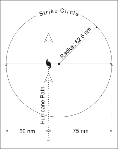
- Strike:
-
 For any particular location, a hurricane
strike occurs if that location passes within the hurricane's strike
circle, a circle of 125 n mi diameter, centered 12.5 n mi to the right
of the hurricane center (looking in the
direction of motion). This circle is meant to depict the typical
extent of hurricane force winds, which are approximately 75 n mi to
the right of the center and 50 n mi to the left.
For any particular location, a hurricane
strike occurs if that location passes within the hurricane's strike
circle, a circle of 125 n mi diameter, centered 12.5 n mi to the right
of the hurricane center (looking in the
direction of motion). This circle is meant to depict the typical
extent of hurricane force winds, which are approximately 75 n mi to
the right of the center and 50 n mi to the left.
- Subtropical Cyclone:
- A non-frontal low-pressure system that has characteristics of both tropical and extratropical cyclones. Like tropical cyclones, they are non-frontal, synoptic-scale cyclones that originate over tropical or subtropical waters, and have a closed surface wind circulation about a well-defined center. In addition, they have organized moderate to deep convection, but lack a central dense overcast. Unlike tropical cyclones, subtropical cyclones derive a significant proportion of their energy from baroclinic sources, and are generally cold-core in the upper troposphere, often being associated with an upper-level low or trough. In comparison to tropical cyclones, these systems generally have a radius of maximum winds occurring relatively far from the center (usually greater than 60 n mi), and generally have a less symmetric wind field and distribution of convection.
- Subtropical Depression:
- A subtropical cyclone in which the maximum sustained surface wind speed (using the U.S. 1-minute average) is 33 kt (38 mph or 62 km/hr) or less.
- Subtropical Storm:
- A subtropical cyclone in which the maximum sustained surface wind speed (using the U.S. 1-minute average) is 34 kt (39 mph or 63 km/hr) or more.
- Synoptic Track:
- Weather reconnaissance mission flown to provide vital meteorological information in data sparse ocean areas as a supplement to existing surface, radar, and satellite data. Synoptic flights better define the upper atmosphere and aid in the prediction of tropical cyclone development and movement.
- Tropical Cyclone:
- A warm-core non-frontal synoptic-scale cyclone, originating over tropical or subtropical waters, with organized deep convection and a closed surface wind circulation about a well-defined center. Once formed, a tropical cyclone is maintained by the extraction of heat energy from the ocean at high temperature and heat export at the low temperatures of the upper troposphere. In this they differ from extratropical cyclones, which derive their energy from horizontal temperature contrasts in the atmosphere (baroclinic effects).
- Tropical Cyclone Plan of the Day:
- A coordinated mission plan that tasks operational weather reconnaissance requirements during the next 1100 to 1100 UTC day or as required, describes reconnaissance flights committed to satisfy both operational and research requirements, and identifies possible reconnaissance requirements for the succeeding 24-hour period.
- Tropical Depression:
- A tropical cyclone in which the maximum sustained surface wind speed (using the U.S. 1-minute average) is 33 kt (38 mph or 62 km/hr) or less.
- Tropical Disturbance:
- A discrete tropical weather system of apparently organized convection -- generally 100 to 300 nmi in diameter -- originating in the tropics or subtropics, having a nonfrontal migratory character, and maintaining its identity for 24 hours or more. It may or may not be associated with a detectable perturbation of the wind field.
- Tropical Storm:
- A tropical cyclone in which the maximum sustained surface wind speed (using the U.S. 1-minute average) ranges from 34 kt (39 mph or 63 km/hr) to 63 kt (73 mph or 118 km/hr).
- Tropical Storm Warning:
- An announcement that sustained winds of 34 to 63 knots (39 to 73 mph or 63 to 118 km/hr) are expected somewhere within the specified area within 36 hours in association with a tropical, subtropical, or post-tropical cyclone.
- Tropical Storm Watch:
- An announcement that sustained winds of 34 to 63 knots (39 to 73 mph or 63 to 118 km/hr) are possible within the specified area within 48 hours in association with a tropical, subtropical, or post-tropical cyclone.
- Tropical Wave:
- A trough or cyclonic curvature maximum in the trade-wind easterlies. The wave may reach maximum amplitude in the lower middle troposphere.