ZCZC MIATWOAT ALL
TTAA00 KNHC DDHHMM
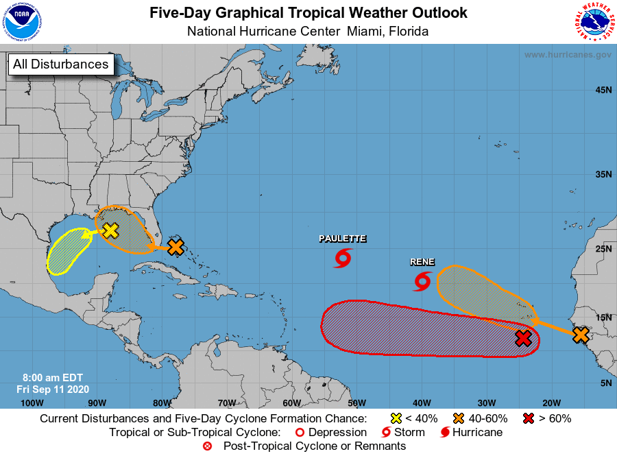
Tropical Weather Outlook
NWS National Hurricane Center Miami FL
800 AM EDT Fri Sep 11 2020
For the North Atlantic...Caribbean Sea and the Gulf of Mexico:
The National Hurricane Center is issuing advisories on Tropical
Storm Paulette, located over the central tropical Atlantic, and on
Tropical Storm Rene, located over the eastern tropical Atlantic.
1. A surface trough of low pressure located over the northwestern
Bahamas is producing a large area of disorganized showers and
thunderstorms that extend from the northwestern and central Bahamas
eastward a few hundred miles over the western Atlantic. This
system is forecast to move westward at about 10 mph, crossing the
Bahamas and Florida today and tonight and moving into the eastern
Gulf of Mexico on Saturday. Upper-level winds are expected to
become conducive for development, and a tropical depression could
form while this system moves slowly west-northwestward over the
eastern Gulf of Mexico this weekend and early next week. Regardless
of development, this system is expected to produce locally heavy
rainfall over portions of the Bahamas, South Florida, and the
Florida Keys during the next couple of days.
* Formation chance through 48 hours...medium...40 percent.
* Formation chance through 5 days...medium...60 percent.
2. Another trough of low pressure is located over the north-central
Gulf of Mexico. Although the associated shower and thunderstorm
activity is currently minimal, some slow development of this system
is possible while it moves westward and then southwestward over the
northern and western Gulf of Mexico through early next week.
* Formation chance through 48 hours...low...10 percent.
* Formation chance through 5 days...low...30 percent.
3. A tropical wave is located a few hundred miles south of the Cabo
Verde Islands and is producing a large area of disorganized showers
and thunderstorms. Development of this system is forecast, and a
tropical depression is expected to form within the next few days
while the system moves generally westward at 15 to 20 mph across
the eastern and central tropical Atlantic.
* Formation chance through 48 hours...high...70 percent.
* Formation chance through 5 days...high...90 percent.
4. Another large area of disturbed weather associated with a tropical
wave is beginning to move off the west coast of Africa.
Environmental conditions appear conducive for development
during the next few days, and a tropical depression could form
over the far eastern tropical Atlantic early next week while the
system moves slowly westward. Upper-level winds could become less
conducive for development by Monday or Tuesday.
* Formation chance through 48 hours...low...10 percent.
* Formation chance through 5 days...medium...40 percent.
Forecaster Berg