ZCZC MIATWOEP ALL
TTAA00 KNHC DDHHMM
Tropical Weather Outlook
NWS National Hurricane Center Miami FL
1100 AM PDT Sat Oct 12 2019
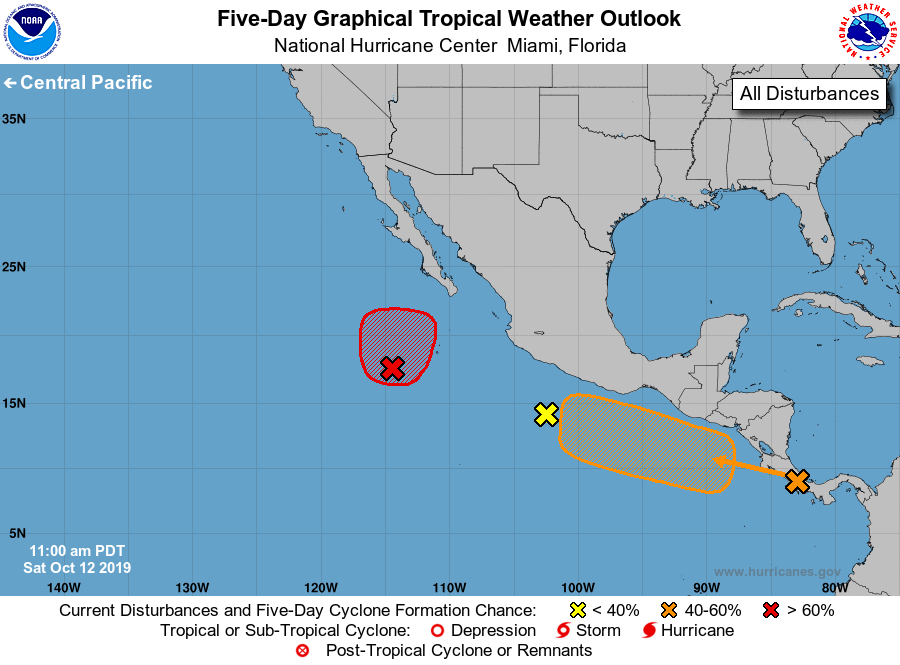
For the eastern North Pacific...east of 140 degrees west longitude:
1. A large area of showers and thunderstorms centered several hundred
miles south-southwest of the southern tip of the Baja California
peninsula is associated with an elongated area of low pressure.
Although shower and thunderstorm activity has changed little over
the past several hours, a tropical depression is still expected to
form tonight or on Sunday while the system moves northward at
5 to 10 mph. By Monday, however, additional development is not
expected due to cooler waters and stronger upper-level winds.
* Formation chance through 48 hours...high...90 percent.
* Formation chance through 5 days...high...90 percent.
2. A broad area of low pressure is forecast to form south of the coast
of southeastern Mexico early next week. Gradual development of
this system is possible after that time, and a tropical depression
could form by midweek while it moves west-northwestward just off the
coast of Mexico.
* Formation chance through 48 hours...low...near 0 percent.
* Formation chance through 5 days...medium...60 percent.
3. A small low pressure system located a few hundred miles south of
Acapulco, Mexico, continues to produce limited shower activity, and
strong upper-level winds are expected to prevent development of a
tropical cyclone.
* Formation chance through 48 hours...low...near 0 percent.
* Formation chance through 5 days...low...near 0 percent.
Forecaster Stewart