


NHC Graphical Outlook Archive
|
« Earliest Available ‹ Earlier Later › Latest Available » |
GIS Shapefiles |
| Eastern North Pacific | Atlantic |
|
Tropical Weather Outlook Text
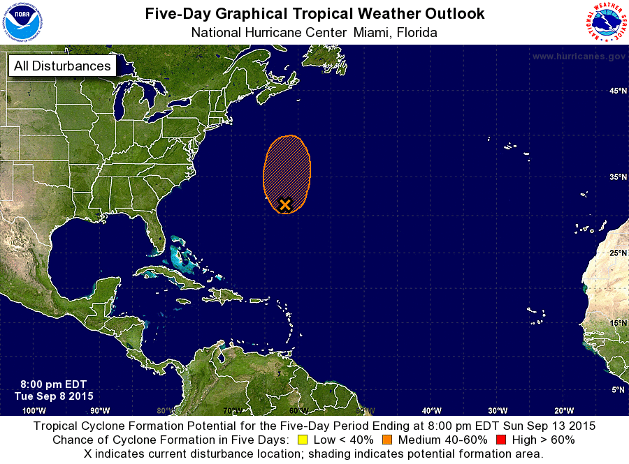
ZCZC MIATWOAT ALL
TTAA00 KNHC DDHHMM

TROPICAL WEATHER OUTLOOK
NWS NATIONAL HURRICANE CENTER MIAMI FL
800 PM EDT TUE SEP 8 2015

For the North Atlantic...Caribbean Sea and the Gulf of Mexico:

The National Hurricane Center is issuing advisories on Tropical
Depression Grace, located about 1100 miles east of the Lesser
Antilles.

1. Satellite imagery indicates that the area of low pressure centered
about 225 miles east-southeast of Bermuda has become better
defined, and that the associated shower activity has become more
concentrated.  Upper-level winds have also become more conducive for
development, and there is some potential for a subtropical or
tropical cyclone to form during the next couple of days.  The low is
expected to remain nearly stationary tonight, and then move
northward at 5 to 10 mph on Wednesday and Thursday.  By Friday or
Saturday, the system should be absorbed by a large extratropical
cyclone.
* Formation chance through 48 hours...medium...60 percent
* Formation chance through 5 days...medium...60 percent

Forecaster Beven
List of Atlantic Outlooks (May 2023 - present)
List of East Pacific Outlooks (May 2023 - present)
List of Central Pacific Outlooks (May 2023 - present)
List of Atlantic Outlooks (July 2014 - April 2023)
List of East Pacific Outlooks (July 2014 - April 2023)
List of Central Pacific Outlooks (June 2019 - April 2023)
List of Atlantic Outlooks (June 2009 - June 2014)
List of East Pacific Outlooks (June 2009 - June 2014)