


NHC Graphical Outlook Archive
|
« Earliest Available ‹ Earlier Later › Latest Available » |
GIS Shapefiles |
| Eastern North Pacific | Atlantic |
|
Tropical Weather Outlook Text
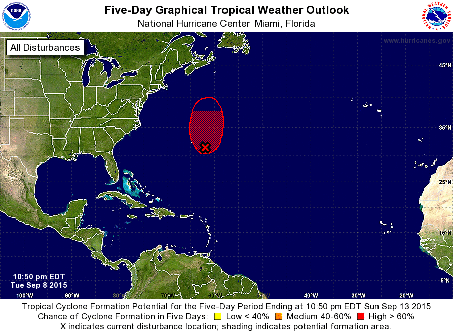
ZCZC MIATWOAT ALL
TTAA00 KNHC DDHHMM

SPECIAL TROPICAL WEATHER OUTLOOK
NWS NATIONAL HURRICANE CENTER MIAMI FL
1050 PM EDT TUE SEP 8 2015

For the North Atlantic...Caribbean Sea and the Gulf of Mexico:

Special tropical weather outlook to update the discussion of the
low pressure area east-southeast of Bermuda.

The National Hurricane Center is issuing advisories on Tropical
Depression Grace, located about 1050 miles east of the Lesser
Antilles.

1. Updated: Recent satellite wind data indicate that the low pressure
area centered about 225 miles east-southeast of Bermuda has
developed a well-defined circulation with winds to near gale force
northeast of the center.  If any further increase in organization
occurs, advisories on a subtropical or tropical cyclone could be
initiated Wednesday morning.  The low is expected to remain nearly
stationary for the remainder of tonight, and then move northward at
5 to 10 mph on Wednesday and Thursday. By Friday or Saturday, the
system should be absorbed by a large extratropical cyclone.
* Formation chance through 48 hours...high...80 percent
* Formation chance through 5 days...high...80 percent

Forecaster Beven
List of Atlantic Outlooks (May 2023 - present)
List of East Pacific Outlooks (May 2023 - present)
List of Central Pacific Outlooks (May 2023 - present)
List of Atlantic Outlooks (July 2014 - April 2023)
List of East Pacific Outlooks (July 2014 - April 2023)
List of Central Pacific Outlooks (June 2019 - April 2023)
List of Atlantic Outlooks (June 2009 - June 2014)
List of East Pacific Outlooks (June 2009 - June 2014)