


NHC Graphical Outlook Archive
|
« Earliest Available ‹ Earlier Later › Latest Available » |
GIS Shapefiles |
| Eastern North Pacific | Atlantic |
|
Tropical Weather Outlook Text
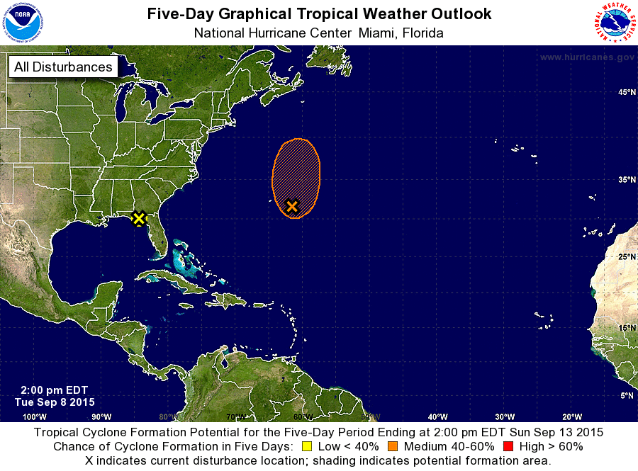
ZCZC MIATWOAT ALL
TTAA00 KNHC DDHHMM

TROPICAL WEATHER OUTLOOK
NWS NATIONAL HURRICANE CENTER MIAMI FL
200 PM EDT TUE SEP 8 2015

For the North Atlantic...Caribbean Sea and the Gulf of Mexico:

The National Hurricane Center is issuing advisories on recently
downgraded Tropical Depression Grace, located about 1200 miles east
of the Lesser Antilles.

1. An area of low pressure has moved inland and is currently located
near Tallahassee, Florida.  This system will move northward to
north-northeastward over land for the next couple of days, and could
produce locally heavy rains over portions of the southeastern United
States.
* Formation chance through 48 hours...low...near 0 percent
* Formation chance through 5 days...low...near 0 percent

2. An area of cloudiness and showers located about 250 miles east-
southeast of Bermuda is associated with a broad area of low
pressure.  Strong upper-level winds are inhibiting the development
of this system, but these winds could become more conducive during
the next couple of days.  The low is expected to remain nearly
stationary today and tonight, and then move northward at 5 to 10 mph
on Wednesday and Thursday.  By Friday, the system should be
absorbed by a large extratropical cyclone.
* Formation chance through 48 hours...medium...40 percent
* Formation chance through 5 days...medium...40 percent

Forecaster Pasch
List of Atlantic Outlooks (May 2023 - present)
List of East Pacific Outlooks (May 2023 - present)
List of Central Pacific Outlooks (May 2023 - present)
List of Atlantic Outlooks (July 2014 - April 2023)
List of East Pacific Outlooks (July 2014 - April 2023)
List of Central Pacific Outlooks (June 2019 - April 2023)
List of Atlantic Outlooks (June 2009 - June 2014)
List of East Pacific Outlooks (June 2009 - June 2014)