


NHC Graphical Outlook Archive
|
« Earliest Available ‹ Earlier Later › Latest Available » |
| Eastern Pacific | Atlantic |
|
|
(mouse over weather symbols for details; click on weather symbols or disturbance numbers to switch views) |
Tropical Weather Outlook Text
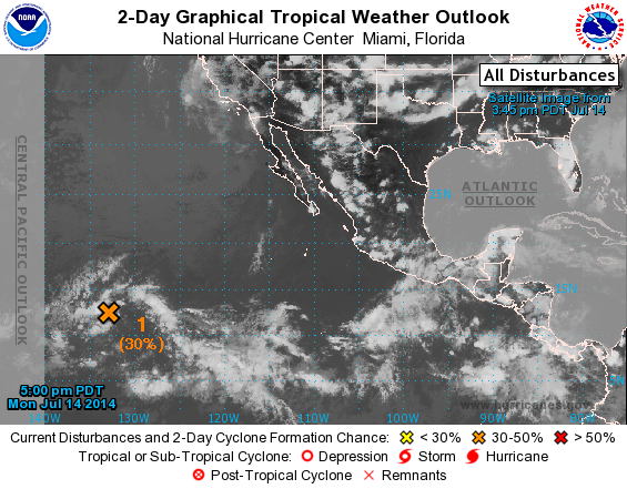
TROPICAL WEATHER OUTLOOK
NWS NATIONAL HURRICANE CENTER MIAMI FL
500 PM PDT MON JUL 14 2014

For the eastern North Pacific...east of 140 degrees west longitude:

1. An area of low pressure located about 1550 miles east-southeast of
the Big Island of Hawaii has become better defined over the past
several hours.  Further development of this system is possible over
the next few days while it moves toward the west or west-northwest
at 10 to 15 mph and into the central Pacific Basin on Wednesday.
* Formation chance through 48 hours...medium...30 percent.
* Formation chance through 5 days...medium...50 percent.

Forecaster Blake
List of Atlantic Outlooks (May 2023 - present)
List of East Pacific Outlooks (May 2023 - present)
List of Central Pacific Outlooks (May 2023 - present)
List of Atlantic Outlooks (July 2014 - April 2023)
List of East Pacific Outlooks (July 2014 - April 2023)
List of Central Pacific Outlooks (June 2019 - April 2023)
List of Atlantic Outlooks (June 2009 - June 2014)
List of East Pacific Outlooks (June 2009 - June 2014)