


NHC Graphical Outlook Archive
|
« Earliest Available ‹ Earlier Later › Latest Available » |
| Eastern Pacific | Atlantic |
|
|
(mouse over weather symbols for details; click on weather symbols or disturbance numbers to switch views) |
Tropical Weather Outlook Text
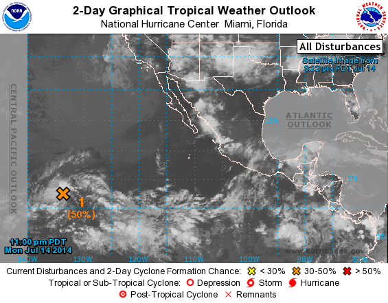
TROPICAL WEATHER OUTLOOK
NWS NATIONAL HURRICANE CENTER MIAMI FL
1100 PM PDT MON JUL 14 2014

For the eastern North Pacific...east of 140 degrees west longitude:

1. Showers and thunderstorms associated with an area of low pressure
located about 1450 miles east-southeast of the Big Island of Hawaii
have become better organized over the past several hours.
Environmental conditions appear to be conducive for further
development, and this system could become a tropical depression
during the next couple of days.  After that time, upper-level winds
are forecast to become less favorable for development.   This low is
expected to move toward the west or west-northwest at 10 to 15 mph
and move into the central Pacific Basin late on Wednesday.
* Formation chance through 48 hours...medium...50 percent.
* Formation chance through 5 days...high...60 percent.

Forecaster Blake
List of Atlantic Outlooks (May 2023 - present)
List of East Pacific Outlooks (May 2023 - present)
List of Central Pacific Outlooks (May 2023 - present)
List of Atlantic Outlooks (July 2014 - April 2023)
List of East Pacific Outlooks (July 2014 - April 2023)
List of Central Pacific Outlooks (June 2019 - April 2023)
List of Atlantic Outlooks (June 2009 - June 2014)
List of East Pacific Outlooks (June 2009 - June 2014)