


NHC Graphical Outlook Archive
|
« Earliest Available ‹ Earlier Later › Latest Available » |
GIS Shapefiles |
| Eastern Pacific | Atlantic |
|
Tropical Weather Outlook Text
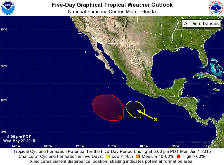
ZCZC MIATWOEP ALL
TTAA00 KNHC DDHHMM

TROPICAL WEATHER OUTLOOK
NWS NATIONAL HURRICANE CENTER MIAMI FL
500 PM PDT WED MAY 27 2015

For the eastern North Pacific...east of 140 degrees west longitude:

1. Showers and thunderstorms associated with an area of low pressure
located about 700 miles south-southwest of Manzanillo, Mexico,
continue to show signs of organization.  This system is expected to
become a tropical depression later this evening or on Thursday while
it moves west-northwestward at 10 to 15 mph.
* Formation chance through 48 hours...high...90 percent
* Formation chance through 5 days...high...90 percent

2. An area of disturbed weather located several hundred miles south of
the Gulf of Tehuantepec is associated with a tropical wave.
Environment conditions could become more favorable for some
development of this system by the weekend while it moves slowly to
the west-northwest.
* Formation chance through 48 hours...low...near 0 percent
* Formation chance through 5 days...low...20 percent

Forecaster Blake
List of Atlantic Outlooks (May 2023 - present)
List of East Pacific Outlooks (May 2023 - present)
List of Central Pacific Outlooks (May 2023 - present)
List of Atlantic Outlooks (July 2014 - April 2023)
List of East Pacific Outlooks (July 2014 - April 2023)
List of Central Pacific Outlooks (June 2019 - April 2023)
List of Atlantic Outlooks (June 2009 - June 2014)
List of East Pacific Outlooks (June 2009 - June 2014)