


NHC Graphical Outlook Archive
|
« Earliest Available ‹ Earlier Later › Latest Available » |
GIS Shapefiles |
| Eastern Pacific | Atlantic |
|
Tropical Weather Outlook Text
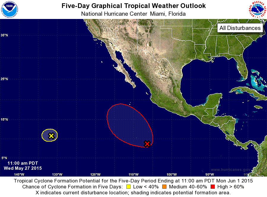
ZCZC MIATWOEP ALL
TTAA00 KNHC DDHHMM

TROPICAL WEATHER OUTLOOK
NWS NATIONAL HURRICANE CENTER MIAMI FL
1100 AM PDT WED MAY 27 2015

For the eastern North Pacific...east of 140 degrees west longitude:

1. Showers and thunderstorms associated with an area of low pressure
located about 800 miles south-southwest of Manzanillo, Mexico,
continue to show signs of organization.  Environmental conditions
are conducive for development and this system is likely to
become a tropical depression during the next day or so while it
moves west-northwestward at 10 to 15 mph.
* Formation chance through 48 hours...high...80 percent
* Formation chance through 5 days...high...90 percent

2. Shower activity remains limited in association with a weak area of
low pressure located about 1550 miles west-southwest of the southern
tip of Baja California. Environmental conditions are expected to
remain unfavorable and development of this system is not
anticipated.
* Formation chance through 48 hours...low...near 0 percent
* Formation chance through 5 days...low...near 0 percent

Forecaster Brown/Roberts
List of Atlantic Outlooks (May 2023 - present)
List of East Pacific Outlooks (May 2023 - present)
List of Central Pacific Outlooks (May 2023 - present)
List of Atlantic Outlooks (July 2014 - April 2023)
List of East Pacific Outlooks (July 2014 - April 2023)
List of Central Pacific Outlooks (June 2019 - April 2023)
List of Atlantic Outlooks (June 2009 - June 2014)
List of East Pacific Outlooks (June 2009 - June 2014)