ZCZC MIATWOEP ALL
TTAA00 KNHC DDHHMM
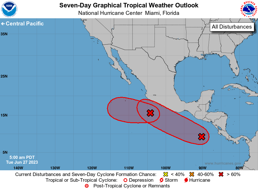
Tropical Weather Outlook
NWS National Hurricane Center Miami FL
500 AM PDT Tue Jun 27 2023
For the eastern North Pacific...east of 140 degrees west longitude:
1. Off the Southwestern Coast of Mexico (EP91):
Showers and thunderstorms continue to show signs of organization in
association with an area of low pressure located a couple of hundred
miles southwest of Zihuatanejo, Mexico. Environmental conditions
appear conducive for additional development, and a tropical
depression is expected to form during the next day or two while the
system moves westward at 5 to 10 mph, generally away from the
southwestern coast of Mexico.
* Formation chance through 48 hours...high...70 percent.
* Formation chance through 7 days...high...90 percent.
2. South of Southern Mexico and Central America:
A broad area of low pressure located a few hundred miles south of
the coasts of Guatemala and El Salvador is producing disorganized
shower and thunderstorm activity. Gradual development of this
system is expected during the next several days, and a tropical
depression is likely to form by the latter part of this week while
it moves west-northwestward at 10 to 15 mph, roughly parallel to the
southern and southwestern coasts of Mexico. Interests along the
southwestern coast of Mexico should monitor the progress of this
system during the next several days.
* Formation chance through 48 hours...medium...50 percent.
* Formation chance through 7 days...high...80 percent.
Forecaster Berg