ZCZC MIATWOEP ALL
TTAA00 KNHC DDHHMM
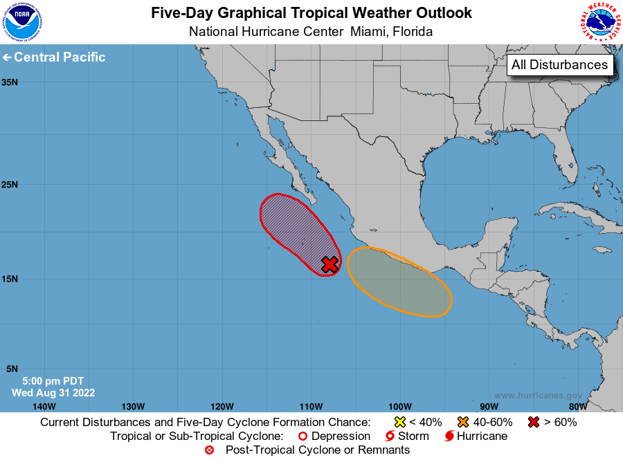
Tropical Weather Outlook
NWS National Hurricane Center Miami FL
500 PM PDT Wed Aug 31 2022
For the eastern North Pacific...east of 140 degrees west longitude:
1. Offshore of West-Central Mexico:
Showers and thunderstorms associated with an area of low pressure
located about 300 miles west-southwest of Manzanillo, Mexico, have
become better organized today. Although the low's circulation
remains somewhat broad and elongated, further development is
expected, and a tropical depression or tropical storm is forecast
to form during the next day or so while moving northwestward at
about 10 mph, likely remaining a couple of hundred miles off the
western coast of Baja California Sur.
* Formation chance through 48 hours...high...80 percent.
* Formation chance through 5 days...high...90 percent.
2. South of Southern Mexico:
An area of low pressure is forecast to form south of the southern
coast of Mexico by late this week. Gradual development of this
system is possible thereafter, and a tropical depression could form
by early next week while the low moves westward or
west-northwestward near the coast of southern and southwestern
Mexico.
* Formation chance through 48 hours...low...near 0 percent.
* Formation chance through 5 days...medium...50 percent.
Forecaster Berg