ZCZC MIATWOEP ALL
TTAA00 KNHC DDHHMM
Tropical Weather Outlook
NWS National Hurricane Center Miami FL
500 AM PDT Sat Aug 6 2022
For the eastern North Pacific...east of 140 degrees west longitude:
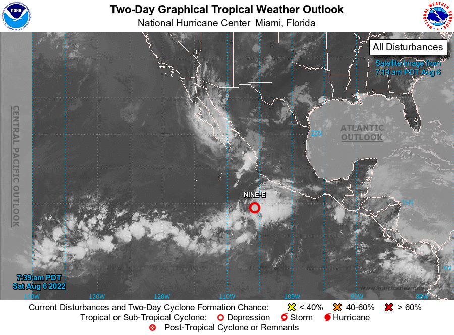
1. Offshore of Southwestern Mexico:
Shower and thunderstorm activity associated with an elongated area
of low pressure located offshore of the coast of southwestern Mexico
continues to show increased signs of organization. If current trends
continue, a tropical depression is likely to form later today or
tonight. The system is forecast to move generally west-northwestward
at about 15 mph through early next week, remaining well offshore of
the coast of southwestern Mexico. Additional information on this
system, including gale warnings, can be found in high seas forecasts
issued by the National Weather Service.
* Formation chance through 48 hours...high...90 percent.
* Formation chance through 5 days...high...90 percent.
2. Well Southeast of the Main Hawaiian Islands:
An area of low pressure could form over the far western portion of
the eastern Pacific basin or the far eastern portion of the central
Pacific basin late this weekend. Environmental conditions could
allow for some gradual development of this system, and a tropical
depression could form when it moves quickly westward over the
central Pacific basin during the early to middle part of next week.
Future information on this system can be found in Tropical Weather
Outlooks issued by the Central Pacific Hurricane Center.
* Formation chance through 48 hours...low...near 0 percent.
* Formation chance through 5 days...medium...40 percent.
High Seas Forecasts issued by the National Weather Service can
be found under AWIPS header NFDHSFEPI, WMO header FZPN02 KWBC, and
on the web at ocean.weather.gov/shtml/NFDHSFEPI.php
Tropical Weather Outlooks issued by the Central Pacific Hurricane
Center can be found under AWIPS header HFOTWOCP, WMO header ACPN50
PHFO, and on the web at hurricanes.gov/?cpac
Forecaster Reinhart