ZCZC MIATWOAT ALL
TTAA00 KNHC DDHHMM
Special Tropical Weather Outlook
NWS National Hurricane Center Miami FL
1150 PM EDT Fri Jul 1 2022
For the North Atlantic...Caribbean Sea and the Gulf of Mexico:
Special outlook issued to update discussion of the low pressure
system along the South Carolina coast.
Active Systems:
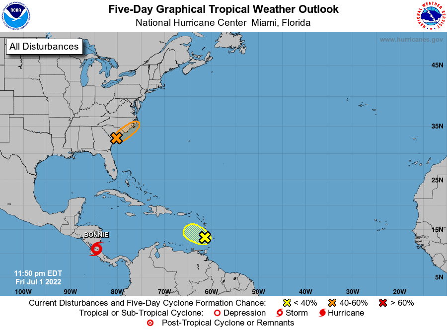
The National Hurricane Center is issuing advisories on Tropical
Storm Bonnie, located near the Nicaragua/Costa Rica border.
1. Near the South Carolina Coast:
Updated: Recent surface observations indicate that a small low
pressure system located just inland to the west of Charleston,
South Carolina, is producing localized areas of winds to tropical
storm force along the South Carolina coast. This system is expected
to move northeastward along the South Carolina and North Carolina
coasts over the weekend, and a tropical depression or tropical storm
could form if the center of the low remains close enough to the
Atlantic waters during that time. Regardless of development, this
system is expected to produce heavy rains, which could cause flash
flooding across coastal portions of the Carolinas over the weekend.
See products issued by the Weather Prediction Center and your local
National Weather Service forecast office for more details.
* Formation chance through 48 hours...medium...40 percent.
* Formation chance through 5 days...medium...40 percent.
2. Near the Windward Islands:
A tropical wave located over the Windward Islands is producing
disorganized showers and thunderstorms. Significant development of
this system is not expected to occur while it moves west-
northwestward into unfavorable conditions over the eastern
Caribbean Sea.
* Formation chance through 48 hours...low...10 percent.
* Formation chance through 5 days...low...10 percent.
For more information on the system near Carolina coast, see products
issued by the National Weather Service at weather.gov and
wpc.ncep.noaa.gov
Forecaster Berg/Papin