ZCZC MIATWOEP ALL
TTAA00 KNHC DDHHMM
Tropical Weather Outlook
NWS National Hurricane Center Miami FL
1100 PM PDT Sun Jun 12 2022
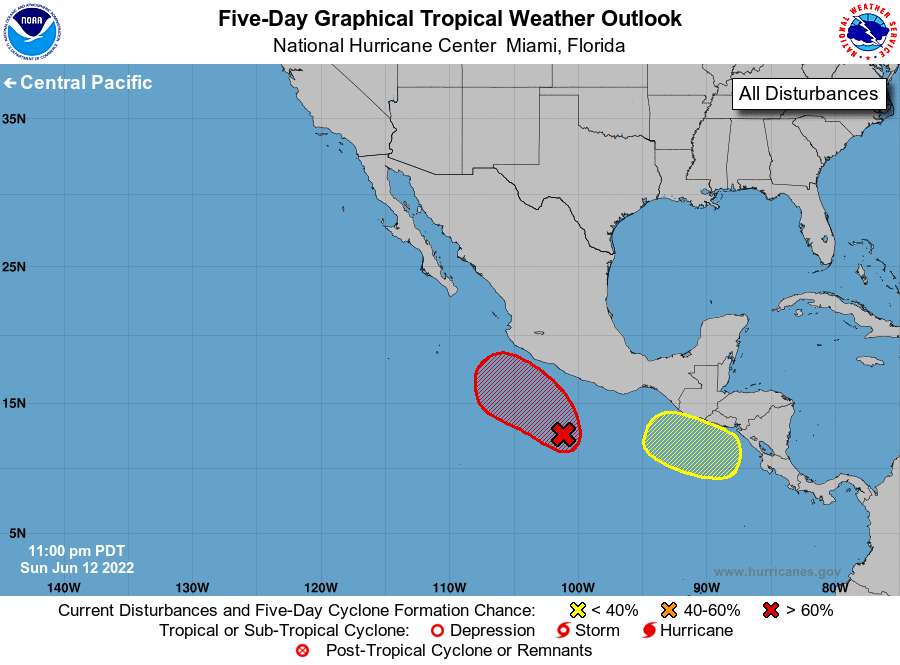
For the eastern North Pacific...east of 140 degrees west longitude:
1. Off the coast of southwestern Mexico:
Showers and thunderstorms are increasing and gradually becoming
better organized in association with a broad area of low pressure
located a few hundred miles south of the southwestern coast of
Mexico. Environmental conditions are forecast to be conducive for
additional development, and a tropical depression is likely to form
in the next day or two while the system moves slowly northwestward
off the southwestern coast of Mexico. Additional information on
this system, including gale warnings, can be found in high seas
forecasts issued by the National Weather Service.
* Formation chance through 48 hours...high...80 percent.
* Formation chance through 5 days...high...90 percent.
2. Off the coast of Central America:
An area of low pressure is expected to form a couple of hundred
miles southwest of the coast of Nicaragua in a day or two. Gradual
development of this system is possible through late week while the
low moves slowly northwestward near the coast of Central America and
southern Mexico.
* Formation chance through 48 hours...low...near 0 percent.
* Formation chance through 5 days...low...20 percent.
High Seas Forecasts issued by the National Weather Service
can be found under AWIPS header NFDHSFEPI, WMO header FZPN02
KWBC, and on the web at ocean.weather.gov/shtml/NFDHSFEPI.php
Forecaster Cangialosi