ZCZC MIATWOAT ALL
TTAA00 KNHC DDHHMM
Tropical Weather Outlook
NWS National Hurricane Center Miami FL
800 PM EDT Fri Aug 6 2021
For the North Atlantic...Caribbean Sea and the Gulf of Mexico:
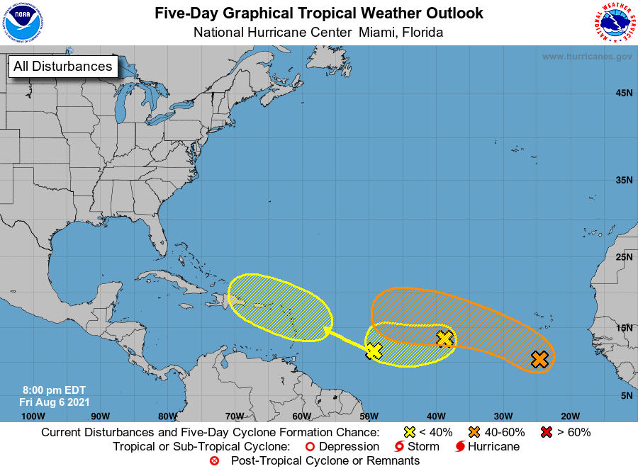
1. A broad area of low pressure located a few hundred miles south of
the Cabo Verde Islands is producing a large area of disorganized
cloudiness and showers. Environmental conditions are expected to be
somewhat conducive for development, and a tropical depression could
form by the early to middle part of next week while the system moves
west-northwestward to westward across the eastern and central
tropical Atlantic at 10 to 15 mph.
* Formation chance through 48 hours...low...30 percent.
* Formation chance through 5 days...medium...50 percent.
2. A small but well-defined area of low pressure located over the
eastern tropical Atlantic about a thousand miles west of the Cabo
Verde Islands is producing limited shower activity. Development of
this system, if any, is expected to be slow to occur while it
drifts toward the west-southwest or west over the central tropical
Atlantic through the middle of next week and potentially interacts
with the broader area of low pressure to its east.
* Formation chance through 48 hours...low...10 percent.
* Formation chance through 5 days...low...20 percent.
3. A tropical wave located over the west-central tropical Atlantic
is producing limited shower activity. Significant development of
this system is not expected as it moves west-northwestward across
the Lesser Antilles and eastern Caribbean Sea during the early to
middle part of next week.
* Formation chance through 48 hours...low...near 0 percent.
* Formation chance through 5 days...low...10 percent.
Forecaster Berg