ZCZC MIATWOEP ALL
TTAA00 KNHC DDHHMM
Tropical Weather Outlook
NWS National Hurricane Center Miami FL
1100 AM PDT Mon Jun 7 2021
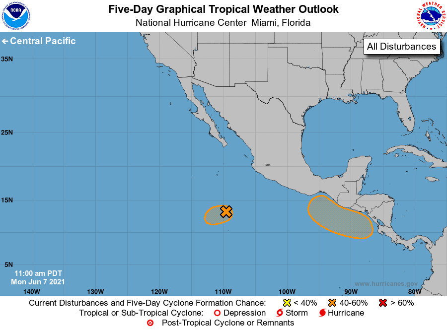
For the eastern North Pacific...east of 140 degrees west longitude:
1. Satellite imagery indicates that an area of low pressure located
about 400 miles south of Socorro Island has developed a well-defined
center. However, the associated shower and thunderstorm activity
is not well-organized. Environmental conditions are expected to
become increasingly unfavorable beginning tonight, and the chances
of a short-lived tropical depression forming are decreasing. The
system is forecast to move slowly west-southwestward during the next
couple of days.
* Formation chance through 48 hours...medium...50 percent.
* Formation chance through 5 days...medium...50 percent.
2. A broad trough of low pressure is expected to form a couple of
hundred miles south of the coasts of southern Mexico, El Salvador,
and Guatemala in a day or two. Environmental conditions appear
favorable for some development thereafter, and a tropical depression
could form by the end of the week as the system moves slowly
northwestward or northward. Regardless of development, this system
could produce heavy rainfall over portions of Central America and
southern Mexico later this week and into the weekend. See products
from your local meteorological service for more information.
* Formation chance through 48 hours...low...near 0 percent.
* Formation chance through 5 days...medium...40 percent.
Forecaster Reinhart/Blake