ZCZC MIATWOAT ALL
TTAA00 KNHC DDHHMM
Tropical Weather Outlook
NWS National Hurricane Center Miami FL
200 AM EDT Mon Oct 19 2020
For the North Atlantic...Caribbean Sea and the Gulf of Mexico:
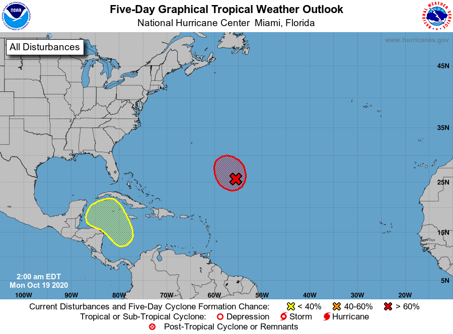
1. Showers and thunderstorms have increased in organization in
association with a large non-tropical low pressure system located
about 700 miles southeast of Bermuda. Although environmental
conditions are expected to be only marginally conducive for
development during the next day or so, a subtropical or tropical
depression could still develop later today or on Tuesday. However,
upper-level winds are forecast to become more favorable for tropical
cyclone formation by late Tuesday and Wednesday while the low
meanders well to the southeast of Bermuda. See NOAA High Seas
Forecast products for more details on this system.
* Formation chance through 48 hours...high...90 percent.
* Formation chance through 5 days...high...90 percent.
2. A broad area of low pressure could form in a couple of days over the
southwestern Caribbean Sea. Some gradual development of this
system is possible late this week while it moves slowly
northwestward or north-northwestward over the western Caribbean Sea.
* Formation chance through 48 hours...low...near 0 percent.
* Formation chance through 5 days...low...20 percent.
High Seas Forecasts issued by the NOAA National Weather Service can
be found under AWIPS header NFDHSFAT1, WMO header FZNT01 KWBC, and
available on the Web at ocean.weather.gov/shtml/NFDHSFAT1.shtml.
Forecaster Stewart