ZCZC MIATWOEP ALL
TTAA00 KNHC DDHHMM
Tropical Weather Outlook
NWS National Hurricane Center Miami FL
500 AM PDT Fri Aug 14 2020
For the eastern North Pacific...east of 140 degrees west longitude:
The National Hurricane Center is issuing advisories on Tropical
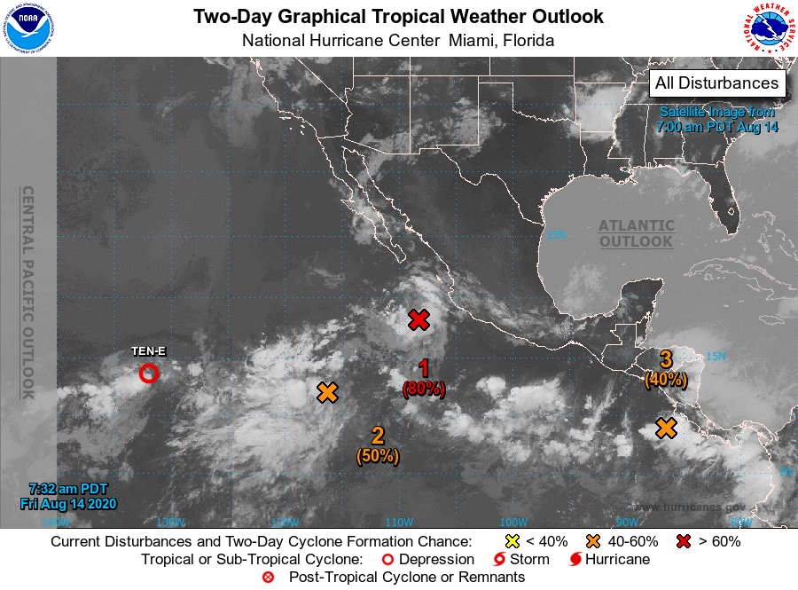
Depression Ten-E, located about 1500 miles west-southwest of the
southern tip of the Baja California peninsula.
1. An elongated area of low pressure stretches from a few hundred miles
south of the southern tip of the Baja California peninsula
southwestward several hundred miles. The northeastern portion of the
trough has slowly organized during the past couple of days and is
producing persistent shower and thunderstorm activity.
Environmental conditions are expected to be conducive for
development and a tropical depression is likely to form during the
next day or so while the system moves west-northwestward or
northwestward at 10 to 15 mph. The system is forecast to move over
colder waters over the weekend and further development is unlikely
after that time.
* Formation chance through 48 hours...high...80 percent.
* Formation chance through 5 days...high...80 percent.
2. The southwestern portion of the aforementioned trough is also
producing a large are of disturbed weather nearly 1000 miles
southwest of the southern tip of the Baja California peninsula.
Environmental conditions are expected to be favorable for the
development of this system and it could become a tropical depression
while it moves slowly northward during the next few days. after that
time.
* Formation chance through 48 hours...medium...50 percent.
* Formation chance through 5 days...medium...60 percent.
3. A trough of low pressure is producing disorganized showers and
thunderstorms just offshore of the Pacific coast of Central America.
Conditions are expected to be conducive for a low pressure system
to develop from this trough over the next couple of days, and a
tropical depression is likely to form this weekend or early next
week while the system moves generally west-northwestward just
offshore of the southwestern coast of Mexico.
* Formation chance through 48 hours...medium...40 percent.
* Formation chance through 5 days...high...80 percent.
Public Advisories on Tropical Depression Ten-E are issued under WMO
header WTPZ35 KNHC and under AWIPS header MIATCPEP5.
Forecast/Advisories on Tropical Depression Ten-E are issued under
WMO header WTPZ25 KNHC and under AWIPS header MIATCMEP5.
Forecaster Zelinsky