ZCZC MIATWOAT ALL
TTAA00 KNHC DDHHMM
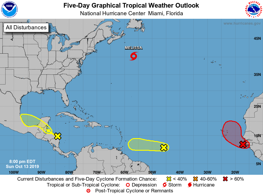
Tropical Weather Outlook
NWS National Hurricane Center Miami FL
800 PM EDT Sun Oct 13 2019
For the North Atlantic...Caribbean Sea and the Gulf of Mexico:
The National Hurricane Center is issuing advisories on Tropical
Storm Melissa, located about 400 miles southeast of Nova Scotia,
Canada.
1. A strong tropical wave, accompanied by a broad area of low pressure,
is located over the far eastern tropical Atlantic Ocean just west of
the west coast of Africa. Although showers and thunderstorms
associated with the system decreased somewhat earlier this evening,
satellite imagery indicates that they are beginning to increase once
again. Environmental conditions are expected to be conducive for
development, and a tropical depression is likely to form during the
next couple of days while the disturbance moves west-northwestward
to northwestward over or just east of the Cabo Verde Islands.
Strong upper-level winds should prevent any further development by
midweek. Regardless of development, this system is likely to bring
locally heavy rainfall and gusty winds to portions of the Cabo Verde
Islands on Monday and Tuesday. Interests in and around the Cabo
Verde Islands should monitor the progress of this system.
* Formation chance through 48 hours...medium...60 percent.
* Formation chance through 5 days...high...70 percent.
2. Disorganized showers and thunderstorm over the southwestern
Caribbean Sea and portions of Central America are associated with
a broad area of low pressure over eastern Honduras. This system is
forecast to continue moving west-northwestward across northern
Honduras, southern Belize, and northern Guatemala, which is likely
to inhibit tropical cyclone formation for the next couple of days
due to land interaction. By Wednesday, however, the disturbance is
forecast to emerge over the southern Bay of Campeche where
conditions could become a little more conducive for some
organization to occur. Regardless of development, this system is
expected to produce heavy rains over portions of Central America
during the next few days, which could cause flooding and mudslides,
especially in mountainous areas.
* Formation chance through 48 hours...low...10 percent.
* Formation chance through 5 days...low...20 percent.
3. A tropical wave located over the central tropical Atlantic is
producing disorganized cloudiness and thunderstorms. Upper-level
winds are not particularly conducive, and any development of this
system over the next few days should be slow to occur while it
moves westward at around 15 mph. By late Wednesday as the
disturbance approaches the southern Lesser Antilles, upper-level
winds are forecast to become quite hostile for any significant
development to occur.
* Formation chance through 48 hours...low...10 percent.
* Formation chance through 5 days...low...20 percent.
Forecaster Brown