ZCZC MIATWOEP ALL
TTAA00 KNHC DDHHMM
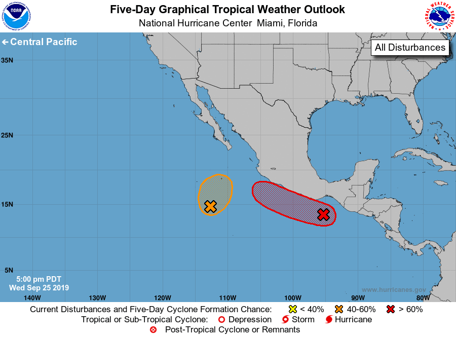
Tropical Weather Outlook
NWS National Hurricane Center Miami FL
500 PM PDT Wed Sep 25 2019
For the eastern North Pacific...east of 140 degrees west longitude:
1. Shower activity associated with a broad area of low pressure several
hundred miles south-southwest of the southern tip of the Baja
California peninsula has become a little more concentrated this
afternoon. Gradual development of this system is possible during the
next day or so, and a tropical depression could form while it moves
slowly northward. By this weekend, conditions are expected to become
unfavorable for further development.
* Formation chance through 48 hours...medium...40 percent.
* Formation chance through 5 days...medium...40 percent.
2. An area of low pressure is expected to form within a couple hundred
miles of the southern coast of Mexico during the next day or two. A
tropical depression is likely to form over the weekend or early next
week while the system moves generally west-northwestward at 10 to 15
mph near the southern and southwestern coasts of Mexico. Regardless
of development, this system could bring heavy rainfall over southern
and southwestern Mexico this weekend and into early next week.
* Formation chance through 48 hours...low...10 percent.
* Formation chance through 5 days...high...70 percent.
Forecaster Latto