ZCZC MIATWOAT ALL
TTAA00 KNHC DDHHMM
Tropical Weather Outlook
NWS National Hurricane Center Miami FL
200 PM EDT Sun Sep 1 2019
For the North Atlantic...Caribbean Sea and the Gulf of Mexico:
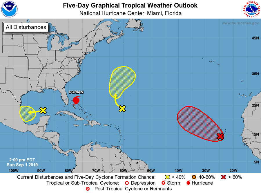
The National Hurricane Center is issuing advisories on Hurricane
Dorian, located over the Abacos Islands.
1. A broad area of low pressure centered near the Cabo Verde Islands is
producing a large area of showers and thunderstorms. This system is
showing signs of becoming better organized, and environmental
conditions appear conducive for additional development during the
next several days. A tropical depression is likely to form by the
middle of the week while the system moves generally northwestward
across the eastern tropical Atlantic Ocean. Heavy rainfall is
possible over portions of the southern Cabo Verde Islands during the
next day or so, and interests on those islands should monitor the
progress of this system.
* Formation chance through 48 hours...medium...60 percent.
* Formation chance through 5 days...high...70 percent.
2. Another broad area of low pressure is located over the south-central
Gulf of Mexico. This disturbance continues to produce widespread
disorganized showers. Some gradual development of this system is
possible during the next few days while it moves slowly westward
across the southern and southwestern Gulf of Mexico toward the coast
of Mexico.
* Formation chance through 48 hours...low...20 percent.
* Formation chance through 5 days...low...30 percent.
3. A trough of low pressure is located several hundred miles
south-southeast of Bermuda. Although the associated shower and
thunderstorm activity is showing some signs of organization, the
system does not currently have a closed surface circulation. Some
gradual development of this disturbance is possible during the next
few days while it moves slowly northward or north-northwestward.
* Formation chance through 48 hours...low...10 percent.
* Formation chance through 5 days...low...30 percent.
Forecaster Zelinsky