ZCZC MIATWOEP ALL
TTAA00 KNHC DDHHMM
Tropical Weather Outlook
NWS National Hurricane Center Miami FL
1100 AM PDT Fri Nov 2 2018
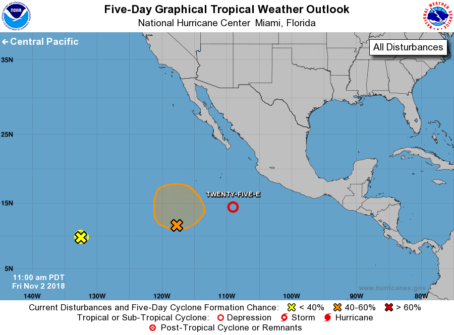
For the eastern North Pacific...east of 140 degrees west longitude:
1. Satellite imagery indicates that shower activity associated with
the low pressure area centered about 600 miles south of the
southern tip of the Baja California peninsula has become better
organized, and that the circulation of the low is becoming better
defined. If current trends continue, advisories will be initiated
on a tropical depression this afternoon or tonight as the system
moves northeastward. Interests along the southwestern coast of
mainland Mexico should monitor the progress of this system
* Formation chance through 48 hours...high...near 100 percent.
* Formation chance through 5 days...high...near 100 percent.
2. Showers and thunderstorms associated with a broad area of low
pressure located about 1700 miles southwest of the southern tip of
the Baja California peninsula have diminished since yesterday, and
upper-level winds continue to become less conducive. Development
of this system is no longer expected.
* Formation chance through 48 hours...low...near 0 percent.
* Formation chance through 5 days...low...near 0 percent.
3. An area of disturbed weather is located about 1000 miles southwest
of the southern tip of the Baja California peninsula. Some
development of this system is possible during the next several days
as it moves slowly northward to northeastward.
* Formation chance through 48 hours...low...20 percent.
* Formation chance through 5 days...medium...40 percent.
Forecaster Beven