ZCZC MIATWOEP ALL
TTAA00 KNHC DDHHMM
Tropical Weather Outlook
NWS National Hurricane Center Miami FL
1100 AM PDT Mon Jul 16 2018
For the eastern North Pacific...east of 140 degrees west longitude:
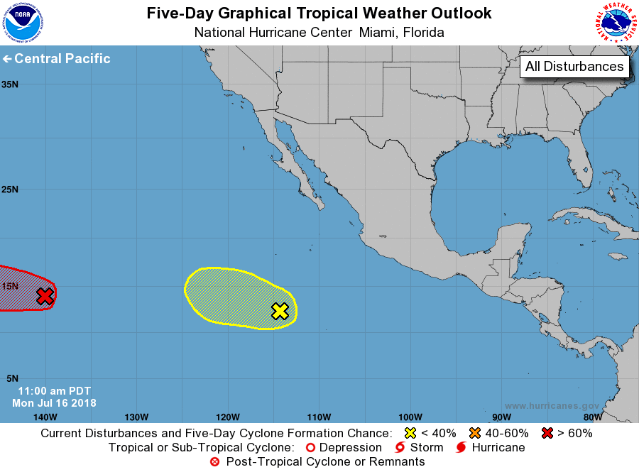
1. Showers and thunderstorms in association with a low pressure system
located about 1050 miles east-southeast of the Big Island of Hawaii
continue to show signs of organization. Environmental conditions
are expected to be conducive for the development of a tropical
depression during the next day or so before upper-level winds
become less conducive by mid-week. This disturbance has crossed
into the Central Pacific basin, and future information on this
system can be found in Tropical Weather Outlooks issued by the
Central Pacific Hurricane Center.
* Formation chance through 48 hours...high...70 percent.
* Formation chance through 5 days...high...70 percent.
2. Shower and thunderstorm activity associated with a tropical wave
located several hundred miles south-southwest of the southern tip
of the Baja California Peninsula has changed little over the past
several hours. Upper-level winds are forecast to become less
conducive for development over the next few days while the system
moves westward to west-northwestward.
* Formation chance through 48 hours...low...20 percent.
* Formation chance through 5 days...low...20 percent.
Tropical Weather Outlooks by the Central Pacific Hurricane Center
are issued under AWIPS header HFOTWOCP and under WMO header
ACPN50 PHFO, and on the web at www.prh.noaa.gov/cphc/pages/TWO.php
Forecaster Pasch