ZCZC MIATWOEP ALL
TTAA00 KNHC DDHHMM
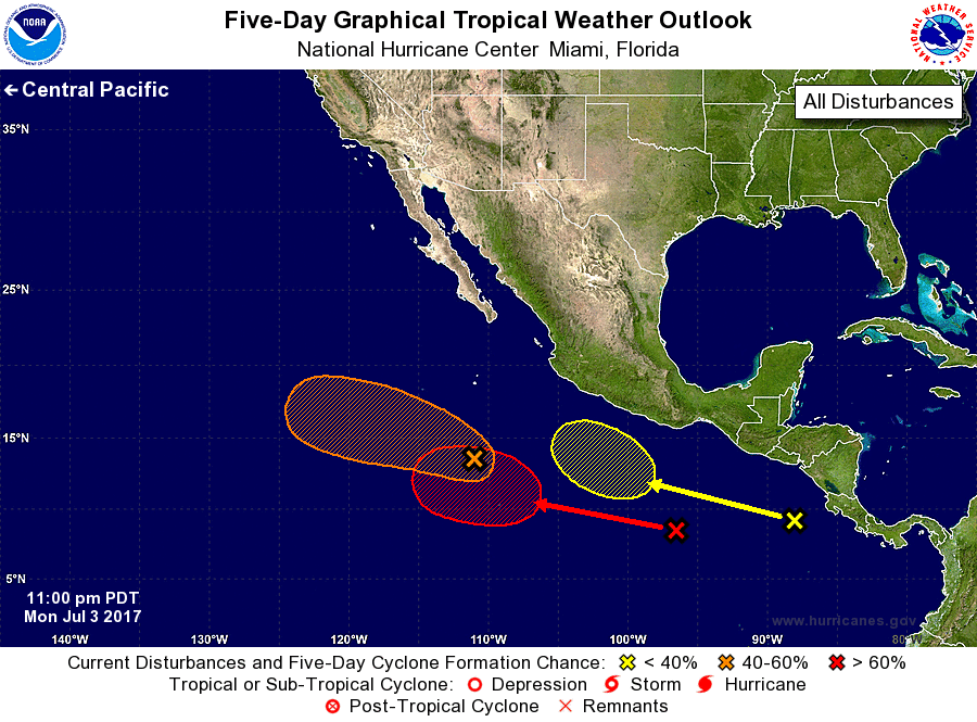
Tropical Weather Outlook
NWS National Hurricane Center Miami FL
1100 PM PDT Mon Jul 3 2017
For the eastern North Pacific...east of 140 degrees west longitude:
1. An area of low pressure located about 650 miles south of the
southern tip of the Baja California peninsula has changed little
during the past several hours. However, environmental conditions
are expected to be conducive for development to occur while the low
moves west-northwestward at 10 to 15 mph, and a tropical depression
could form before the system reaches colder water in a couple of
days.
* Formation chance through 48 hours...medium...60 percent.
* Formation chance through 5 days...medium...60 percent.
2. A tropical wave, accompanied by a broad low pressure system, is
located south-southwest of the Gulf of Tehuantepec. Although
shower activity is currently disorganized, environmental conditions
are forecast to be favorable for development, and a tropical
depression is likely to form later this week while the disturbance
moves westward at about 10 mph.
* Formation chance through 48 hours...low...near 0 percent.
* Formation chance through 5 days...high...70 percent.
3. A third area of disturbed weather is located over the far eastern
North Pacific, south-southwest of the coast of Central America.
Some development of this system is possible late this week while it
moves westward to west-northwestward well south of the coast of
Mexico.
* Formation chance through 48 hours...low...near 0 percent.
* Formation chance through 5 days...low...20 percent.
Forecaster Stewart