Skip Navigation Links
NOAA NOAA United States Department of Commerce

NHC Graphical Outlook Archive


« Earliest Available         ‹ Earlier         Later ›         Latest Available »
GIS Shapefiles
tab Eastern North Pacific tab tab Atlantic tab

View 2-Day Graphical Tropical Weather Outlook
Click for Eastern North Pacific Click for Eastern North Pacific

Tropical Weather Outlook Text

ZCZC MIATWOAT ALL
TTAA00 KNHC DDHHMM

TROPICAL WEATHER OUTLOOK
NWS NATIONAL HURRICANE CENTER MIAMI FL
200 PM EDT FRI OCT 21 2016

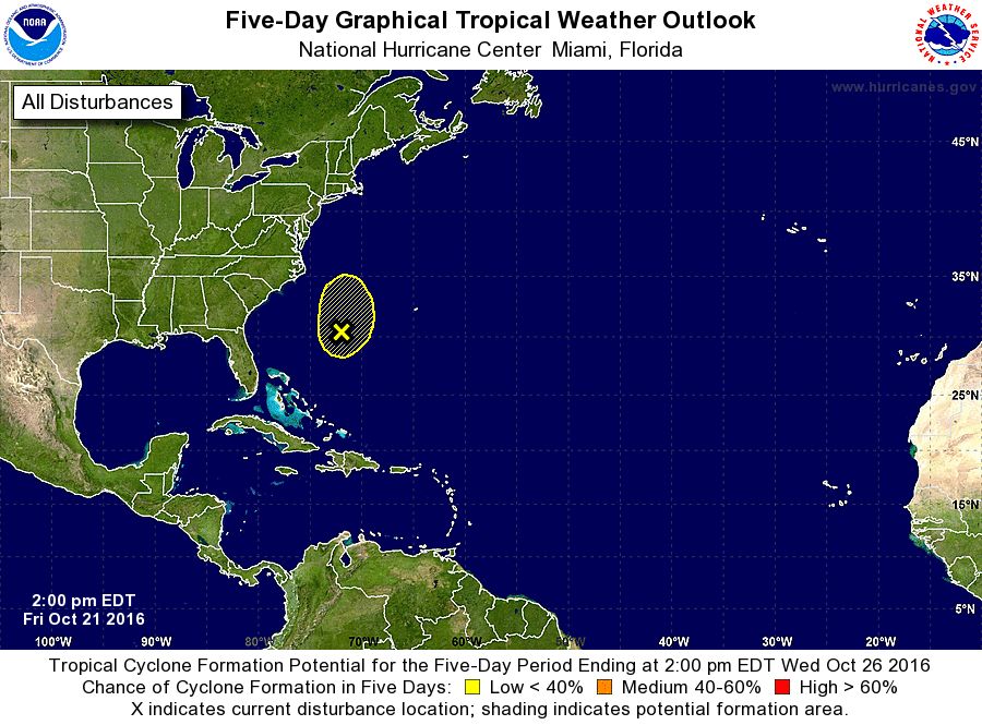
For the North Atlantic...Caribbean Sea and the Gulf of Mexico:

1. A non-tropical area of low pressure located about 400 miles
south-southeast of Cape Hatteras, North Carolina, is expected to
move toward the north-northeast with increasing forward speed later
today.  Increasing upper-level winds are expected to limit the
opportunity for this system to become a subtropical or tropical
cyclone, and this low is expected to degenerate into a trough ahead
of an approaching frontal system tonight or early Saturday.
* Formation chance through 48 hours...low...30 percent
* Formation chance through 5 days...low...30 percent

Forecaster Avila


List of Atlantic Outlooks (May 2023 - present)
List of East Pacific Outlooks (May 2023 - present)
List of Central Pacific Outlooks (May 2023 - present)
List of Atlantic Outlooks (July 2014 - April 2023)
List of East Pacific Outlooks (July 2014 - April 2023)
List of Central Pacific Outlooks (June 2019 - April 2023)
List of Atlantic Outlooks (June 2009 - June 2014)
List of East Pacific Outlooks (June 2009 - June 2014)