ZCZC MIATWOEP ALL
TTAA00 KNHC DDHHMM
TROPICAL WEATHER OUTLOOK
NWS NATIONAL HURRICANE CENTER MIAMI FL
500 AM PDT THU OCT 20 2016
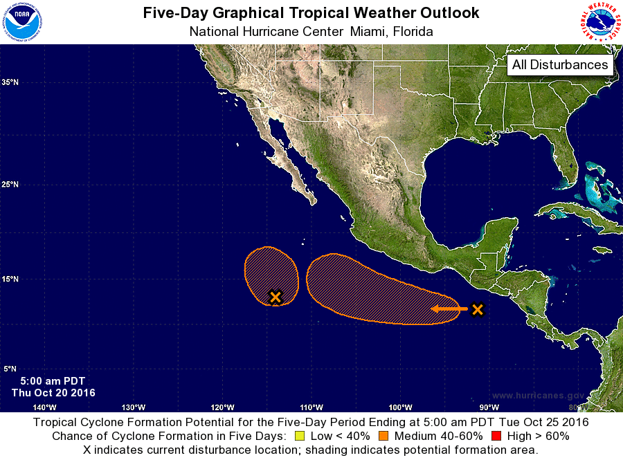
For the eastern North Pacific...east of 140 degrees west longitude:
1. Showers and thunderstorms have increased near a small area of low
pressure located about 700 miles south-southwest of the southern tip
of the Baja California peninsula. Although upper-level winds are
only marginally conducive, this system has the potential to become a
tropical depression over the next couple of days before upper-level
winds become unfavorable for development. The low is expected to
drift northward over the next several days.
* Formation chance through 48 hours...medium...40 percent
* Formation chance through 5 days...medium...40 percent
2. Disorganized cloudiness and showers over the far eastern Pacific
near the coast of Central America are associated with a surface
trough. Environmental conditions are forecast to become more
favorable for some development of this disturbance over the
weekend while the system moves toward the west-northwest at
about 10 to 15 mph. Regardless of development, locally heavy
rainfall is possible over portions of Central America during
the next couple of days.
* Formation chance through 48 hours...low...10 percent
* Formation chance through 5 days...medium...40 percent
Forecaster Blake