ZCZC MIATWOAT ALL
TTAA00 KNHC DDHHMM
SPECIAL TROPICAL WEATHER OUTLOOK
NWS NATIONAL HURRICANE CENTER MIAMI FL
1135 AM EDT WED AUG 24 2016
For the North Atlantic...Caribbean Sea and the Gulf of Mexico:
Special Tropical Weather Outlook issued to update discussion on
tropical wave in the Caribbean.
The National Hurricane Center is issuing advisories on Tropical
Storm Gaston, located about 1000 miles west of the Cabo Verde
Islands.
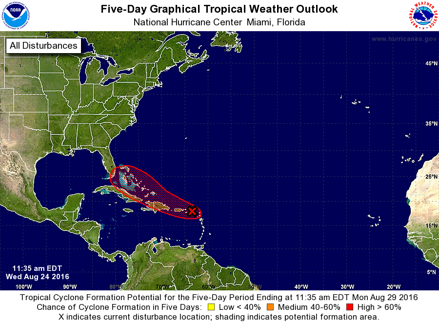
1. Updated: An Air Force Reconnaissance aircraft currently
investigating the broad low pressure area and tropical wave near
the northern Leeward Islands has found winds to tropical storm force
in a few squalls near the northernmost Leeward Islands. Squalls to
tropical storm force can be expected over the extreme northern
Leeward Islands and portions of the northern U.S. and British Virgin
Islands this afternoon. The reconnaissance aircraft mission is
ongoing to determine whether or not a tropical cyclone has formed.
Although environmental conditions are currently only marginally
conducive for additional development, this system could become a
tropical depression or tropical storm at any time during the next
few days while it moves west-northwestward at about 15 mph across
the northern Leeward Islands, near or over Puerto Rico, Hispaniola,
and the Bahamas. Strong winds, heavy rains, and possible flash
floods and mudslides are expected to occur over portions of the
Leeward Islands, Puerto Rico, Hispaniola, and the southeastern and
central Bahamas. Please consult products issued by your local
meteorological offices for further details. Interests in the
northwestern Bahamas and Florida should also monitor the progress
of this system.
* Formation chance through 48 hours...medium...60 percent
* Formation chance through 5 days...high...80 percent
Forecaster Brown