ZCZC MIATWOAT ALL
TTAA00 KNHC DDHHMM
TROPICAL WEATHER OUTLOOK
NWS NATIONAL HURRICANE CENTER MIAMI FL
800 AM EDT SUN JUL 31 2016
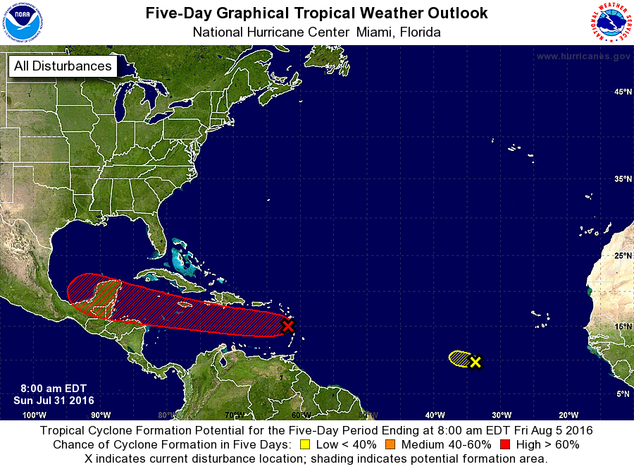
For the North Atlantic...Caribbean Sea and the Gulf of Mexico:
1. Showers and thunderstorms associated with a strong and fast-moving
tropical wave now entering the extreme eastern Caribbean Sea are
disorganized, while satellite data and surface observations indicate
no signs of a closed surface circulation. Although some gradual
development of this system is possible during the next couple of
days, the chance for tropical cyclone formation should increase
after the wave reaches the western Caribbean Sea in a couple of
days. This disturbance is expected to bring locally heavy rains and
gusty winds to portions of the Lesser Antilles, the Virgin Islands,
and Puerto Rico today. These conditions should spread westward
across the eastern and central Caribbean Sea tonight and reach
Hispaniola on Monday. Interests in these areas and elsewhere in the
Caribbean Sea should continue to monitor the progress of this
system. For additional information on this system, see High Seas
Forecasts issued by the National Weather Service.
* Formation chance through 48 hours...medium...40 percent
* Formation chance through 5 days...high...70 percent
2. Disorganized shower and thunderstorm activity associated with a
tropical wave located nearly 700 miles west-southwest of the Cabo
Verde Islands has changed little in organization. This system should
continue moving westward at 10 to 15 mph, and development is
unlikely due to unfavorable upper-level winds.
* Formation chance through 48 hours...low...near 0 percent
* Formation chance through 5 days...low...near 0 percent
High Seas Forecasts issued by the National Weather Service can be
found under AWIPS header NFDHSFAT1, WMO header FZNT01 KWBC, and on
the Web at http://www.opc.ncep.noaa.gov/shtml/NFDHSFAT1.shtml.
Forecaster Kimberlain