


NHC Graphical Outlook Archive
|
« Earliest Available ‹ Earlier Later › Latest Available » |
GIS Shapefiles |
| Eastern North Pacific | Atlantic |
|
Tropical Weather Outlook Text
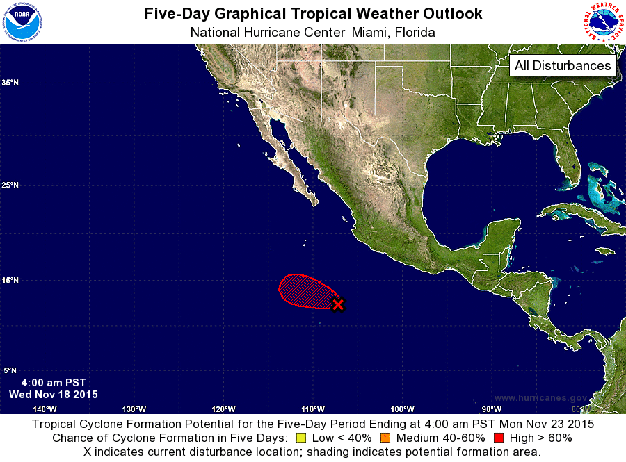
ZCZC MIATWOEP ALL
TTAA00 KNHC DDHHMM

TROPICAL WEATHER OUTLOOK
NWS NATIONAL HURRICANE CENTER MIAMI FL
400 AM PST WED NOV 18 2015

For the eastern North Pacific...east of 140 degrees west longitude:

1. A concentrated area of showers and thunderstorms is associated with
a low pressure system located about 700 miles south-southeast of
the southern tip of the Baja California peninsula.  Satellite data
indicate that the circulation of the low has become much better
defined overnight.  Environmental conditions are conducive for
additional development, and a tropical depression is likely to form
during the next day or so while this disturbance moves toward the
west-northwest or northwest.
* Formation chance through 48 hours...medium...60 percent
* Formation chance through 5 days...high...80 percent

Forecaster Kimberlain/Brown
List of Atlantic Outlooks (May 2023 - present)
List of East Pacific Outlooks (May 2023 - present)
List of Central Pacific Outlooks (May 2023 - present)
List of Atlantic Outlooks (July 2014 - April 2023)
List of East Pacific Outlooks (July 2014 - April 2023)
List of Central Pacific Outlooks (June 2019 - April 2023)
List of Atlantic Outlooks (June 2009 - June 2014)
List of East Pacific Outlooks (June 2009 - June 2014)