


NHC Graphical Outlook Archive
|
« Earliest Available ‹ Earlier Later › Latest Available » |
GIS Shapefiles |
| Eastern North Pacific | Atlantic |
|
Tropical Weather Outlook Text
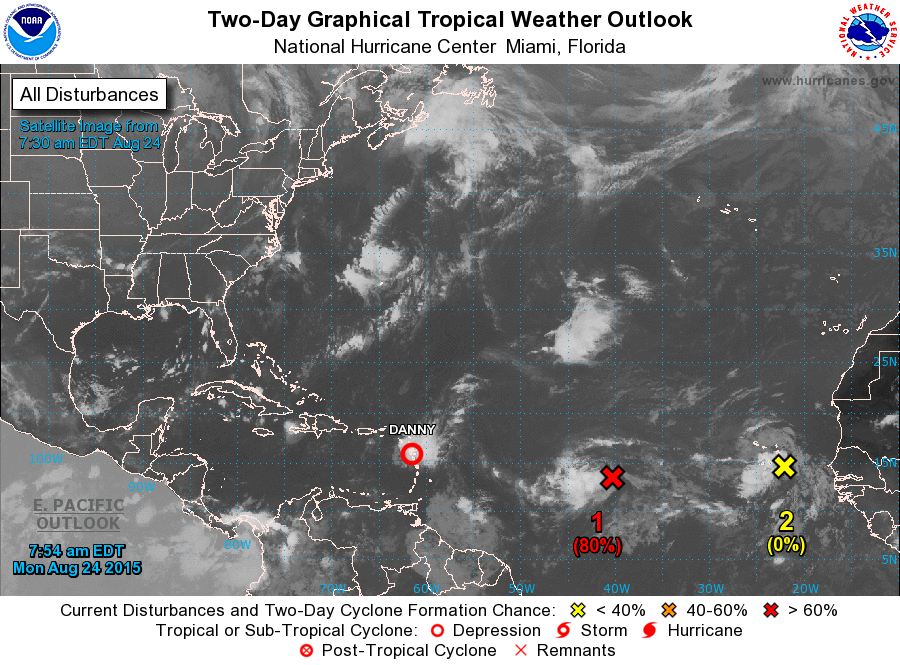
ZCZC MIATWOAT ALL
TTAA00 KNHC DDHHMM

TROPICAL WEATHER OUTLOOK
NWS NATIONAL HURRICANE CENTER MIAMI FL
200 AM EDT MON AUG 24 2015

For the North Atlantic...Caribbean Sea and the Gulf of Mexico:

The National Hurricane Center is issuing advisories on Tropical
Storm Danny, located just east of the Leeward Islands.

1. Shower and thunderstorm activity continues to become show signs of
organization this morning in association with a low pressure system
located about midway between Africa and the Windward Islands. The
low is gradually becoming better defined and environmental
conditions are conducive for additional development, and a tropical
depression could form later today or on Tuesday while the system
moves westward at around 20 mph.
* Formation chance through 48 hours...high...80 percent
* Formation chance through 5 days...high...90 percent

2. A tropical wave located near the easternmost Cape Verde Islands is
accompanied by disorganized showers and thunderstorms. Environmental
conditions are expected to be only marginally favorable for
development while the wave moves generally westward over the
tropical Atlantic Ocean at 15 to 20 mph this week. However, locally
heavy rainfall and gusty winds will be possible across the Cape
Verde Islands today.
* Formation chance through 48 hours...low...near 0 percent
* Formation chance through 5 days...low...20 percent

Forecaster Stewart
List of Atlantic Outlooks (May 2023 - present)
List of East Pacific Outlooks (May 2023 - present)
List of Central Pacific Outlooks (May 2023 - present)
List of Atlantic Outlooks (July 2014 - April 2023)
List of East Pacific Outlooks (July 2014 - April 2023)
List of Central Pacific Outlooks (June 2019 - April 2023)
List of Atlantic Outlooks (June 2009 - June 2014)
List of East Pacific Outlooks (June 2009 - June 2014)