


NHC Graphical Outlook Archive
|
« Earliest Available ‹ Earlier Later › Latest Available » |
GIS Shapefiles |
| Eastern North Pacific | Atlantic |
|
Tropical Weather Outlook Text
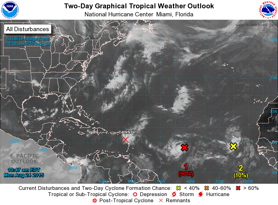
ZCZC MIATWOAT ALL
TTAA00 KNHC DDHHMM

TROPICAL WEATHER OUTLOOK
NWS NATIONAL HURRICANE CENTER MIAMI FL
800 AM EDT MON AUG 24 2015

For the North Atlantic...Caribbean Sea and the Gulf of Mexico:

The National Hurricane Center is issuing advisories on recently
downgraded Tropical Depression Danny, located near the Leeward
Islands.

1. Shower and thunderstorm activity associated with a low pressure
system located about 1250 miles east of the southern Lesser Antilles
has continued to become better organized since yesterday. Satellite
data also indicates that the low's circulation is gradually becoming
better defined. If current trends continue, a tropical depression is
likely to form later today or tonight while the low moves westward
at around 20 mph.
* Formation chance through 48 hours...high...90 percent
* Formation chance through 5 days...high...90 percent

2. A tropical wave located near the Cape Verde Islands is accompanied
by disorganized showers and thunderstorms. Environmental conditions
are expected to be only marginally conducive across the tropical
Atlantic Ocean this week, and development of this system is unlikely
while it moves generally westward at 15 to 20 mph. Locally heavy
rainfall and gusty winds are possible across portions of the Cape
Verde Islands today.
* Formation chance through 48 hours...low...near 10 percent
* Formation chance through 5 days...low...10 percent

Forecaster Kimberlain
List of Atlantic Outlooks (May 2023 - present)
List of East Pacific Outlooks (May 2023 - present)
List of Central Pacific Outlooks (May 2023 - present)
List of Atlantic Outlooks (July 2014 - April 2023)
List of East Pacific Outlooks (July 2014 - April 2023)
List of Central Pacific Outlooks (June 2019 - April 2023)
List of Atlantic Outlooks (June 2009 - June 2014)
List of East Pacific Outlooks (June 2009 - June 2014)