


NHC Graphical Outlook Archive
|
« Earliest Available ‹ Earlier Later › Latest Available » |
GIS Shapefiles |
| Eastern North Pacific | Atlantic |
|
Tropical Weather Outlook Text
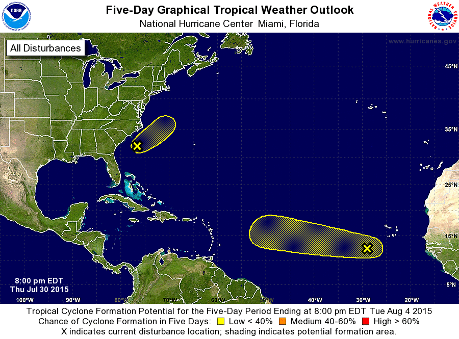
ZCZC MIATWOAT ALL
TTAA00 KNHC DDHHMM

TROPICAL WEATHER OUTLOOK
NWS NATIONAL HURRICANE CENTER MIAMI FL
800 PM EDT THU JUL 30 2015

For the North Atlantic...Caribbean Sea and the Gulf of Mexico:

1. A tropical wave accompanied by an area of low pressure is
located a few hundred miles southwest of the Cape Verde Islands.
This disturbance continues to produce disorganized showers and
thunderstorms, and some slow development of the system is possible
into early next week while it moves westward at about 15 mph.
* Formation chance through 48 hours...low...10 percent
* Formation chance through 5 days...low...30 percent

2. Disorganized showers and thunderstorms continue in association with
an elongated area of low pressure located a couple of hundred
miles east of the South Carolina coast. This low is expected to move
northeastward and merge with a frontal system on Friday, and
significant development is unlikely.
* Formation chance through 48 hours...low...10 percent
* Formation chance through 5 days...low...10 percent

Forecaster Cangialosi
List of Atlantic Outlooks (May 2023 - present)
List of East Pacific Outlooks (May 2023 - present)
List of Central Pacific Outlooks (May 2023 - present)
List of Atlantic Outlooks (July 2014 - April 2023)
List of East Pacific Outlooks (July 2014 - April 2023)
List of Central Pacific Outlooks (June 2019 - April 2023)
List of Atlantic Outlooks (June 2009 - June 2014)
List of East Pacific Outlooks (June 2009 - June 2014)