


NHC Graphical Outlook Archive
|
« Earliest Available ‹ Earlier Later › Latest Available » |
| Eastern Pacific | Atlantic |
|
|
(mouse over weather symbols for details; click on weather symbols or disturbance numbers to switch views) |
Tropical Weather Outlook Text
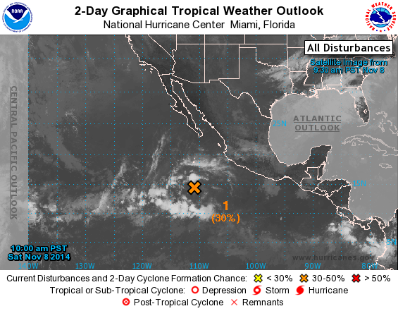
TROPICAL WEATHER OUTLOOK
NWS NATIONAL HURRICANE CENTER MIAMI FL
1000 AM PST SAT NOV 8 2014

For the eastern North Pacific...east of 140 degrees west longitude:

1. Shower and thunderstorm activity associated with a low pressure
system located several hundred miles southwest of Manzanillo,
Mexico, has become less organized since yesterday.  There is still
some potential for development of this system over the weekend.
However, upper-level winds are expected to become unfavorable for
development by Monday.
* Formation chance through 48 hours...medium...30 percent.
* Formation chance through 5 days...medium...30 percent.

Forecaster Beven
List of Atlantic Outlooks (May 2023 - present)
List of East Pacific Outlooks (May 2023 - present)
List of Central Pacific Outlooks (May 2023 - present)
List of Atlantic Outlooks (July 2014 - April 2023)
List of East Pacific Outlooks (July 2014 - April 2023)
List of Central Pacific Outlooks (June 2019 - April 2023)
List of Atlantic Outlooks (June 2009 - June 2014)
List of East Pacific Outlooks (June 2009 - June 2014)