


NHC Graphical Outlook Archive
|
« Earliest Available ‹ Earlier Later › Latest Available » |
| Eastern Pacific | Atlantic |
|
|
(mouse over shaded areas for details; click on shaded areas or disturbance numbers to switch views) |
Tropical Weather Outlook Text
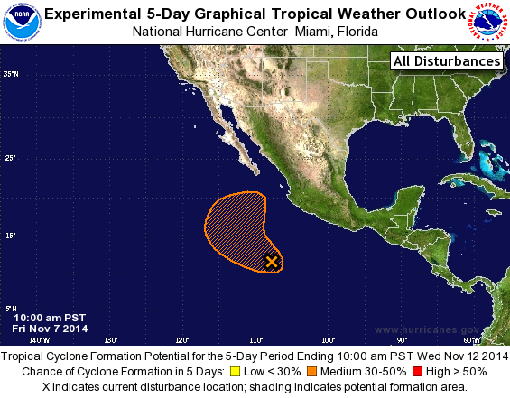
TROPICAL WEATHER OUTLOOK
NWS NATIONAL HURRICANE CENTER MIAMI FL
1000 AM PST FRI NOV 7 2014

For the eastern North Pacific...east of 140 degrees west longitude:

1. Shower and thunderstorm activity associated with a low pressure
system located several hundred miles south of Manzanillo, Mexico,
continue to show signs of organization. Environmental conditions are
expected to be conducive for development of this disturbance for
about the next three days while it moves generally northwestward at
10 to 15 mph.  After that time, upper-level winds are expected to
become unfavorable for development.
* Formation chance through 48 hours...medium...30 percent.
* Formation chance through 5 days...medium...50 percent.

Forecaster Beven
List of Atlantic Outlooks (May 2023 - present)
List of East Pacific Outlooks (May 2023 - present)
List of Central Pacific Outlooks (May 2023 - present)
List of Atlantic Outlooks (July 2014 - April 2023)
List of East Pacific Outlooks (July 2014 - April 2023)
List of Central Pacific Outlooks (June 2019 - April 2023)
List of Atlantic Outlooks (June 2009 - June 2014)
List of East Pacific Outlooks (June 2009 - June 2014)