


NHC Graphical Outlook Archive
|
« Earliest Available ‹ Earlier Later › Latest Available » |
| Eastern Pacific | Atlantic |
|
|
(mouse over shaded areas for details; click on shaded areas or disturbance numbers to switch views) |
Tropical Weather Outlook Text
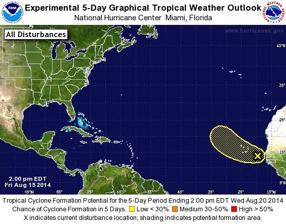
TROPICAL WEATHER OUTLOOK
NWS NATIONAL HURRICANE CENTER MIAMI FL
200 PM EDT FRI AUG 15 2014

For the North Atlantic...Caribbean Sea and the Gulf of Mexico:

1. A low pressure area associated with a tropical wave is centered
between the west coast of Africa and the Cape Verde Islands.
Although the shower activity has become a little better organized
during the past few hours, the low is heading west-northwestward
toward an environment unfavorable for development.
* Formation chance through 48 hours...low...10 percent.
* Formation chance through 5 day...low...10 percent.

Forecaster Avila
List of Atlantic Outlooks (May 2023 - present)
List of East Pacific Outlooks (May 2023 - present)
List of Central Pacific Outlooks (May 2023 - present)
List of Atlantic Outlooks (July 2014 - April 2023)
List of East Pacific Outlooks (July 2014 - April 2023)
List of Central Pacific Outlooks (June 2019 - April 2023)
List of Atlantic Outlooks (June 2009 - June 2014)
List of East Pacific Outlooks (June 2009 - June 2014)