


NHC Graphical Outlook Archive
|
« Earliest Available ‹ Earlier Later › Latest Available » |
| Eastern Pacific | Atlantic |
|
|
(mouse over shaded areas for details; click on shaded areas or disturbance numbers to switch views) |
Tropical Weather Outlook Text
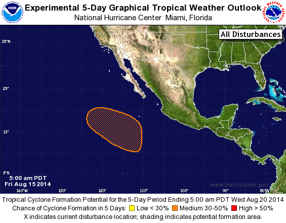
TROPICAL WEATHER OUTLOOK
NWS NATIONAL HURRICANE CENTER MIAMI FL
500 AM PDT FRI AUG 15 2014

For the eastern North Pacific...east of 140 degrees west longitude:

The National Hurricane Center is issuing advisories on recently
downgraded Tropical Storm Karina, located several hundred miles
west-southwest of the southern tip of the Baja California peninsula.

1. An area of low pressure is forecast to form a few hundred miles
southwest of the southern tip of the Baja California peninsula in a
couple of days.  Some gradual development of this system is possible
early next week while it moves northwestward and then west-
northwestward.
* Formation chance through 48 hours...low...near 0 percent.
* Formation chance through 5 day...medium...30 percent.

Forecaster Landsea
List of Atlantic Outlooks (May 2023 - present)
List of East Pacific Outlooks (May 2023 - present)
List of Central Pacific Outlooks (May 2023 - present)
List of Atlantic Outlooks (July 2014 - April 2023)
List of East Pacific Outlooks (July 2014 - April 2023)
List of Central Pacific Outlooks (June 2019 - April 2023)
List of Atlantic Outlooks (June 2009 - June 2014)
List of East Pacific Outlooks (June 2009 - June 2014)