


NHC Graphical Outlook Archive
|
« Earliest Available ‹ Earlier Later › Latest Available » |
| Eastern Pacific | Atlantic |
|
|
(mouse over shaded areas for details; click on shaded areas or disturbance numbers to switch views) |
Tropical Weather Outlook Text
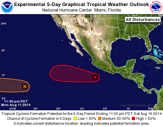
TROPICAL WEATHER OUTLOOK
NWS NATIONAL HURRICANE CENTER MIAMI FL
1100 PM PDT MON AUG 11 2014

For the eastern North Pacific...east of 140 degrees west longitude:

1. A tropical wave located a few hundred miles south-southeast of
Manzanillo, Mexico is producing a large area of cloudiness and
showers. Although the thunderstorm activity has recently weakened,
environmental conditions are conducive for development, and a
tropical depression is likely to form within a few days while the
system moves west-northwestward at 10 to 15 mph.
* Formation chance through 48 hours...medium...50 percent.
* Formation chance through 5 days...high...90 percent.

2. A broad area of low pressure centered about 1500 miles east-
southeast of the Big Island of Hawaii is producing disorganized
showers and thunderstorms.  Some slow development of this system is
possible over the next few days while it moves to the west or
west-northwest at 10 to 15 mph.
* Formation chance through 48 hours...low...10 percent.
* Formation chance through 5 days...medium...30 percent.

Forecaster Blake
List of Atlantic Outlooks (May 2023 - present)
List of East Pacific Outlooks (May 2023 - present)
List of Central Pacific Outlooks (May 2023 - present)
List of Atlantic Outlooks (July 2014 - April 2023)
List of East Pacific Outlooks (July 2014 - April 2023)
List of Central Pacific Outlooks (June 2019 - April 2023)
List of Atlantic Outlooks (June 2009 - June 2014)
List of East Pacific Outlooks (June 2009 - June 2014)