


NHC Graphical Outlook Archive
|
« Earliest Available ‹ Earlier Later › Latest Available » |
| Eastern Pacific | Atlantic |
|
|
(mouse over shaded areas for details; click on shaded areas or disturbance numbers to switch views) |
Tropical Weather Outlook Text
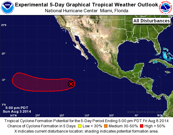
TROPICAL WEATHER OUTLOOK
NWS NATIONAL HURRICANE CENTER MIAMI FL
500 PM PDT SUN AUG 3 2014

For the eastern North Pacific...east of 140 degrees west longitude:

The National Hurricane Center is issuing advisories on Hurricane
Iselle, located more than a thousand miles east of the Hawaiian
Islands.

Satellite images indicate that showers and thunderstorms associated
with a low pressure area located about 775 miles southwest of the
southern tip of the Baja California peninsula have more concentrated
and better organized this afternoon.  If current trends continue,
tropical depression advisories would be initiated this evening or
later tonight while the low moves generally westward around 10 mph.

1. * Formation chance through 48 hours...high...90 percent.
* Formation chance through 5 days...high...near 100 percent.

Forecaster Brown
List of Atlantic Outlooks (May 2023 - present)
List of East Pacific Outlooks (May 2023 - present)
List of Central Pacific Outlooks (May 2023 - present)
List of Atlantic Outlooks (July 2014 - April 2023)
List of East Pacific Outlooks (July 2014 - April 2023)
List of Central Pacific Outlooks (June 2019 - April 2023)
List of Atlantic Outlooks (June 2009 - June 2014)
List of East Pacific Outlooks (June 2009 - June 2014)