ZCZC MIATWOEP ALL
TTAA00 KNHC DDHHMM
Tropical Weather Outlook
NWS National Hurricane Center Miami FL
500 PM PDT Fri Aug 3 2018
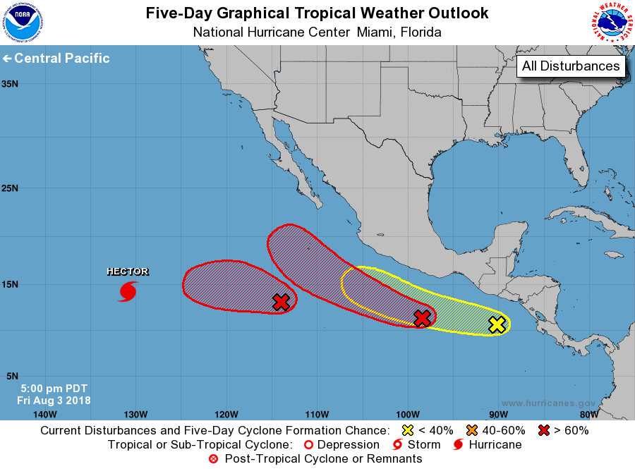
For the eastern North Pacific...east of 140 degrees west longitude:
The National Hurricane Center is issuing advisories on Hurricane
Hector, located well southwest of Baja California Sur.
1. Satellite imagery indicates that shower activity associated with a
low pressure area centered about 750 miles south-southwest of the
southern tip of Baja California is becoming better organized.
Environmental conditions appear conducive for further development,
and a tropical depression is likely to form over the weekend or
early next week. The low is forecast to move slowly westward over
the next few days.
* Formation chance through 48 hours...medium...60 percent.
* Formation chance through 5 days...high...90 percent.
2. A large area of disturbed weather centered several hundred miles
southwest of the Gulf of Tehuantepec has become a little better
organized since yesterday. Environmental conditions are expected to
be conducive for development during the next several days, and a
tropical depression or tropical storm is expected to form by early
next week while it moves west-northwestward off the coast of Mexico.
* Formation chance through 48 hours...medium...50 percent.
* Formation chance through 5 days...high...90 percent.
3. A tropical wave to the south of the coasts of Guatemala and El
Salvador is producing disorganized cloudiness and showers. While
development of this system is possible over the next several days,
strong upper-level winds from another disturbance to the west and
northwest could prevent significant organization. The wave is
expected to move westward or west-northwestward during the next few
days.
* Formation chance through 48 hours...low...20 percent.
* Formation chance through 5 days...low...30 percent.
Forecaster Beven