ZCZC MIATWOEP ALL
TTAA00 KNHC DDHHMM
Tropical Weather Outlook
NWS National Hurricane Center Miami FL
1100 PM PDT Fri Aug 3 2018
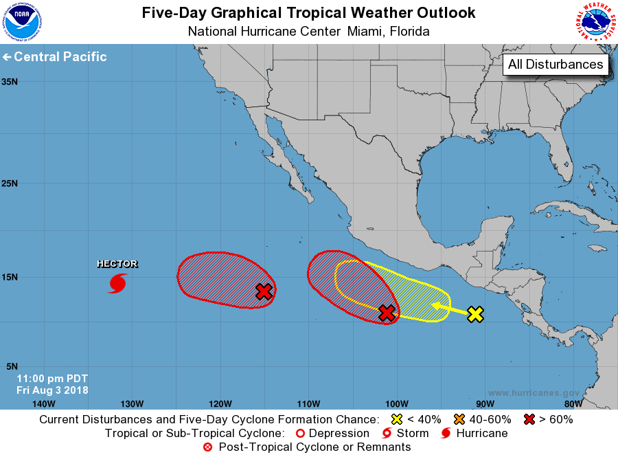
For the eastern North Pacific...east of 140 degrees west longitude:
The National Hurricane Center is issuing advisories on Hurricane
Hector, located well southwest of Baja California Sur.
1. Showers and thunderstorms associated with an area of low
pressure centered about 800 miles south-southwest of the southern
tip of the Baja California peninsula have changed little in
organization over the past several hours. Environmental conditions
are expected to support additional development and a tropical
depression is likely to form by early next week as the system moves
slowly westward.
* Formation chance through 48 hours...medium...60 percent.
* Formation chance through 5 days...high...90 percent.
2. A large area of disturbed weather centered several hundred miles
southwest of the Gulf of Tehuantepec continues to show signs of
becoming better organized. Environmental conditions appear
conducive for development and a tropical depression or tropical
storm is expected form within the next few days while the system
moves west-northwestward off the coast of Mexico.
* Formation chance through 48 hours...high...70 percent.
* Formation chance through 5 days...high...90 percent.
3. A tropical wave located south of the coast of Guatemala continues
to produce disorganized shower activity. While development of this
system is possible over the next several days, strong upper-level
winds from another disturbance to the west could prevent significant
organization. The wave is expected to move westward or
west-northwestward during the next few days.
* Formation chance through 48 hours...low...20 percent.
* Formation chance through 5 days...low...30 percent.
Forecaster Zelinsky