Skip Navigation Links
NOAA NOAA United States Department of Commerce

NHC Graphical Outlook Archive


« Earliest Available         ‹ Earlier         Later ›         Latest Available »
GIS Shapefiles
tab Eastern North Pacific tab tab Atlantic tab

View 2-Day Graphical Tropical Weather Outlook
Click for Atlantic Click for Atlantic

Tropical Weather Outlook Text

ZCZC MIATWOEP ALL
TTAA00 KNHC DDHHMM

Tropical Weather Outlook
NWS National Hurricane Center Miami FL
500 AM PDT Sun Oct 15 2017

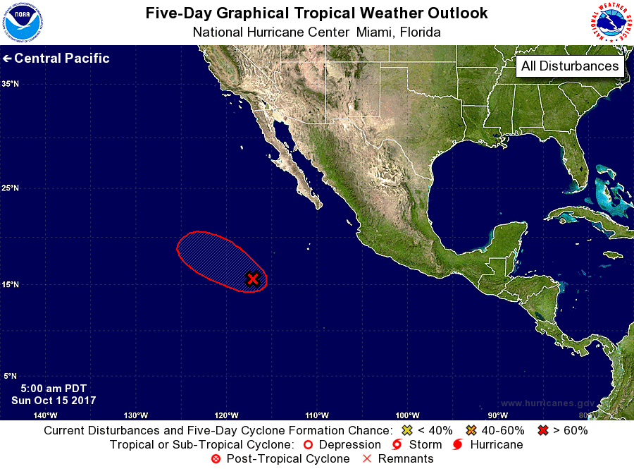
For the eastern North Pacific...east of 140 degrees west longitude:

1. A low pressure system located several hundred miles southwest of the
southern tip of the Baja California peninsula continues to produce
widespread showers and thunderstorms.  Environmental conditions
appear conducive for a tropical depression to form during the next
day or so while the system moves west-northwestward to northwestward
at 10 to 15 mph.  After that time, cold SSTs and strong upper-level
winds are likely to prevent further development.
* Formation chance through 48 hours...high...80 percent.
* Formation chance through 5 days...high...80 percent.

Forecaster Zelinsky


List of Atlantic Outlooks (May 2023 - present)
List of East Pacific Outlooks (May 2023 - present)
List of Central Pacific Outlooks (May 2023 - present)
List of Atlantic Outlooks (July 2014 - April 2023)
List of East Pacific Outlooks (July 2014 - April 2023)
List of Central Pacific Outlooks (June 2019 - April 2023)
List of Atlantic Outlooks (June 2009 - June 2014)
List of East Pacific Outlooks (June 2009 - June 2014)