


NHC Graphical Outlook Archive
|
« Earliest Available ‹ Earlier Later › Latest Available » |
GIS Shapefiles |
| Eastern North Pacific | Atlantic |
|
Tropical Weather Outlook Text
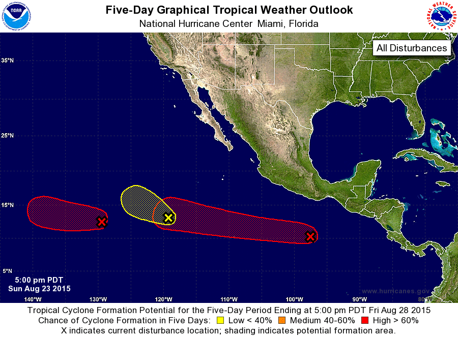
ZCZC MIATWOEP ALL
TTAA00 KNHC DDHHMM

TROPICAL WEATHER OUTLOOK
NWS NATIONAL HURRICANE CENTER MIAMI FL
500 PM PDT SUN AUG 23 2015

For the eastern North Pacific...east of 140 degrees west longitude:

1. Showers and thunderstorms are showing signs of organization in
association with a slow-moving low pressure area located about 1450
miles southwest of the southern tip of the Baja California
peninsula.  Environmental conditions are expected to be conducive
for gradual development, and a tropical depression is likely to form
in a few days while the low moves west-northwestward at 10 mph.
* Formation chance through 48 hours...medium...50 percent
* Formation chance through 5 days...high...70 percent

2. A large area of disorganized cloudiness and showers located
several hundred miles south-southwest of the southern tip of the
Baja California peninsula is associated with a surface trough.
Development of this system is unlikely since it is expected to
gradually lose its identity or merge with the disturbance to its
west.  The system should move northwestward, and then
west-northwestward at about 10 at 15 mph over the next few days.
* Formation chance through 48 hours...low...10 percent
* Formation chance through 5 days...low...10 percent

3. Disorganized showers and thunderstorms located several hundred
miles south of the coast of southwestern Mexico are associated with
a tropical wave.  Environmental conditions are expected to be
conducive for gradual development, and a tropical depression is
likely to form late this week while this system moves westward and
then west-northwestward at 10 to 15 mph.
* Formation chance through 48 hours...low...10 percent
* Formation chance through 5 days...high...80 percent

Forecaster Blake
List of Atlantic Outlooks (May 2023 - present)
List of East Pacific Outlooks (May 2023 - present)
List of Central Pacific Outlooks (May 2023 - present)
List of Atlantic Outlooks (July 2014 - April 2023)
List of East Pacific Outlooks (July 2014 - April 2023)
List of Central Pacific Outlooks (June 2019 - April 2023)
List of Atlantic Outlooks (June 2009 - June 2014)
List of East Pacific Outlooks (June 2009 - June 2014)