


NHC Graphical Outlook Archive
|
« Earliest Available ‹ Earlier Later › Latest Available » |
| Eastern Pacific | Atlantic |
|
|
(mouse over shaded areas for details; click on shaded areas or disturbance numbers to switch views) |
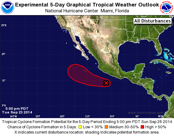
Tropical Weather Outlook Text
TROPICAL WEATHER OUTLOOK
NWS NATIONAL HURRICANE CENTER MIAMI FL
500 PM PDT TUE SEP 23 2014

For the eastern North Pacific...east of 140 degrees west longitude:

1. Showers and thunderstorms associated with a low pressure area
located a couple of hundred miles southwest of Acapulco, Mexico,
have again changed little in organization during the past several
hours.  Upper-level winds are currently not favorable for
significant development.  However, they are expected to become more
favorable during the next couple of days, and any increase in
organization would lead to the formation of a tropical depression.
The low is expected to move westward or west-northwestward at about
10 mph well offshore of the coast of Mexico.
* Formation chance through 48 hours...high...70 percent.
* Formation chance through 5 days...high...90 percent.

Forecaster Beven
List of Atlantic Outlooks (May 2023 - present)
List of East Pacific Outlooks (May 2023 - present)
List of Central Pacific Outlooks (May 2023 - present)
List of Atlantic Outlooks (July 2014 - April 2023)
List of East Pacific Outlooks (July 2014 - April 2023)
List of Central Pacific Outlooks (June 2019 - April 2023)
List of Atlantic Outlooks (June 2009 - June 2014)
List of East Pacific Outlooks (June 2009 - June 2014)