


NHC Graphical Outlook Archive
|
« Earliest Available ‹ Earlier Later › Latest Available » |
| Eastern Pacific | Atlantic |
|
|
(mouse over shaded areas for details; click on shaded areas or disturbance numbers to switch views) |
Tropical Weather Outlook Text
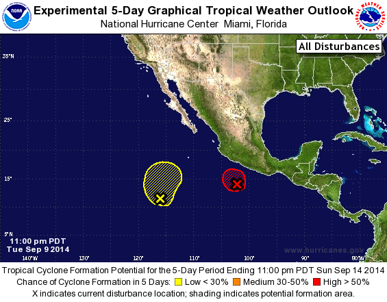
TROPICAL WEATHER OUTLOOK
NWS NATIONAL HURRICANE CENTER MIAMI FL
1100 PM PDT TUE SEP 9 2014

For the eastern North Pacific...east of 140 degrees west longitude:

1. Shower and thunderstorm activity has increased in association with
an area of low pressure centered about 250 miles south-southwest of
Acapulco, Mexico. If current trends continue, advisories will likely
be initiated on a tropical depression overnight tonight while the
system moves slowly northwestward just offshore of the southwestern
coast of Mexico.
* Formation chance through 48 hours...high...near 100 percent.
* Formation chance through 5 days...high...near 100 percent.

2. A small area of low pressure located about 900 miles south-
southwest of the southern tip of the Baja California peninsula has
changed little in organization during the past few hours.
Significant development of this system is not anticipated while it
moves generally northward and then northeastward during the next
couple of days.
* Formation chance through 48 hours...low...20 percent.
* Formation chance through 5 days...low...20 percent.

Forecaster Brennan
List of Atlantic Outlooks (May 2023 - present)
List of East Pacific Outlooks (May 2023 - present)
List of Central Pacific Outlooks (May 2023 - present)
List of Atlantic Outlooks (July 2014 - April 2023)
List of East Pacific Outlooks (July 2014 - April 2023)
List of Central Pacific Outlooks (June 2019 - April 2023)
List of Atlantic Outlooks (June 2009 - June 2014)
List of East Pacific Outlooks (June 2009 - June 2014)