


NHC Graphical Outlook Archive
|
« Earliest Available ‹ Earlier Later › Latest Available » |
| Eastern Pacific | Atlantic |
|
|
(mouse over shaded areas for details; click on shaded areas or disturbance numbers to switch views) |
Tropical Weather Outlook Text
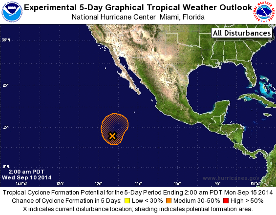
SPECIAL TROPICAL WEATHER OUTLOOK
NWS NATIONAL HURRICANE CENTER MIAMI FL
200 AM PDT WED SEP 10 2014

For the eastern North Pacific...east of 140 degrees west longitude:

Special outlook issued to update the discussion of the low pressure
area located south-southwest of the southern tip of Baja
California.

The National Hurricane Center is issuing advisories on newly formed
Tropical Depression Fifteen-E, located a couple hundred miles
southwest of Acapulco, Mexico.

1. Updated: Shower and thunderstorm activity has increased in
association with an area of low pressure located about 800 miles
south-southwest of the southern tip of the Baja California
peninsula. Also, recent satellite wind data indicate that the
circulation center has become a little better defined. Some
additional development of this system is possible during the next
couple of days as it moves generally northward and then
northeastward.
* Formation chance through 48 hours...medium...40 percent.
* Formation chance through 5 days...medium...40 percent.

Public Advisories on Tropical Depression Fifteen-E are issued under
WMO header WTPZ35 KNHC and under AWIPS header MIATCPEP5.
Forecast/Advisories on Fifteen-E are issued under WMO header WTPZ25
KNHC and under AWIPS header MIATCMEP5.

Forecaster Brennan
List of Atlantic Outlooks (May 2023 - present)
List of East Pacific Outlooks (May 2023 - present)
List of Central Pacific Outlooks (May 2023 - present)
List of Atlantic Outlooks (July 2014 - April 2023)
List of East Pacific Outlooks (July 2014 - April 2023)
List of Central Pacific Outlooks (June 2019 - April 2023)
List of Atlantic Outlooks (June 2009 - June 2014)
List of East Pacific Outlooks (June 2009 - June 2014)