


NHC Graphical Outlook Archive
|
« Earliest Available ‹ Earlier Later › Latest Available » |
| Eastern Pacific | Atlantic |
|
|
(mouse over shaded areas for details; click on shaded areas or disturbance numbers to switch views) |
Tropical Weather Outlook Text
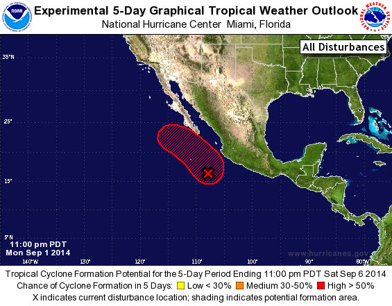
TROPICAL WEATHER OUTLOOK
NWS NATIONAL HURRICANE CENTER MIAMI FL
1100 PM PDT MON SEP 1 2014

For the eastern North Pacific...east of 140 degrees west longitude:

1. Showers and thunderstorms appear to be consolidating near a
developing low pressure system located about 300 miles southwest of
Manzanillo, Mexico.  Environmental conditions are expected to be
conducive for further development, and a tropical depression could
form in the next day or two while the system moves slowly northward
and then northwestward.  Locally heavy rains are possible over
portions of southwestern Mexico during the next few days and could
cause life-threatening flash floods and mudslides.  Interests
along the southwestern coast of Mexico and the extreme southern
Baja California peninsula should monitor the progress of this
disturbance during the next few days.
* Formation chance through 48 hours...medium...50 percent.
* Formation chance through 5 days...high...80 percent.

Forecaster Berg
List of Atlantic Outlooks (May 2023 - present)
List of East Pacific Outlooks (May 2023 - present)
List of Central Pacific Outlooks (May 2023 - present)
List of Atlantic Outlooks (July 2014 - April 2023)
List of East Pacific Outlooks (July 2014 - April 2023)
List of Central Pacific Outlooks (June 2019 - April 2023)
List of Atlantic Outlooks (June 2009 - June 2014)
List of East Pacific Outlooks (June 2009 - June 2014)