


NHC Graphical Outlook Archive
|
« Earliest Available ‹ Earlier Later › Latest Available » |
| Eastern Pacific | Atlantic |
|
|
(mouse over shaded areas for details; click on shaded areas or disturbance numbers to switch views) |
Tropical Weather Outlook Text
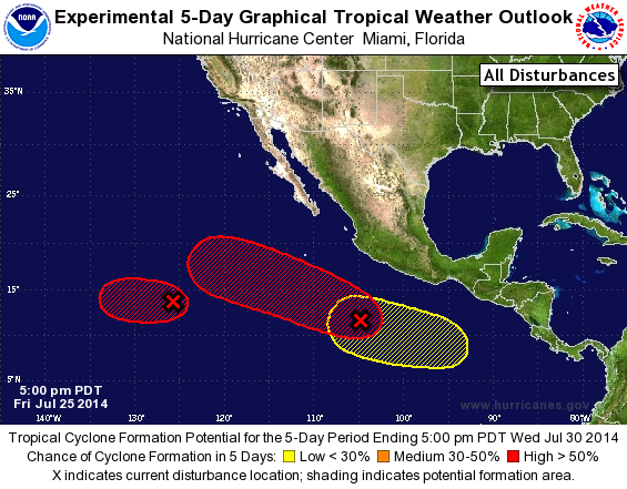
TROPICAL WEATHER OUTLOOK
NWS NATIONAL HURRICANE CENTER MIAMI FL
500 PM PDT FRI JUL 25 2014

For the eastern North Pacific...east of 140 degrees west longitude:

The National Hurricane Center is issuing advisories on Tropical
Storm Genevieve, located more than a thousand miles east-southeast
of Hilo, Hawaii.

1. Shower activity associated with a westward-moving area of low
pressure centered about 1175 miles southwest of the southern tip of
the Baja California peninsula continues to become better organized.
There is potential for a tropical depression to form during the next
day or so before upper-level winds become less favorable for
development.
* Formation chance through 48 hours...high...60 percent.
* Formation chance through 5 days...high...60 percent.

2. Showers and thunderstorms continue to become better organized in
association with a low pressure area located about 500 miles south
of Manzanillo, Mexico.  Conditions appear to be favorable for
additional development, and a tropical depression could form during
the next day or two as the system moves west-northwestward at 10 to
15 mph.
* Formation chance through 48 hours...high...60 percent.
* Formation chance through 5 days...high...70 percent.

3. Another area of low pressure is forecast to form well south of
southeastern Mexico late this weekend.  Some gradual development of
this system is possible after that time.
* Formation chance through 48 hours...low...near 0 percent.
* Formation chance through 5 days...low...20 percent.

Public Advisories on Genevieve are issued under WMO header
WTPZ32 KNHC and under AWIPS header MIATCPEP2. Forecast/Advisories
are issued under WMO header WTPZ22 KNHC and under AWIPS
header MIATCMEP2.

Forecaster Beven
List of Atlantic Outlooks (May 2023 - present)
List of East Pacific Outlooks (May 2023 - present)
List of Central Pacific Outlooks (May 2023 - present)
List of Atlantic Outlooks (July 2014 - April 2023)
List of East Pacific Outlooks (July 2014 - April 2023)
List of Central Pacific Outlooks (June 2019 - April 2023)
List of Atlantic Outlooks (June 2009 - June 2014)
List of East Pacific Outlooks (June 2009 - June 2014)