


NHC Graphical Outlook Archive
|
« Earliest Available ‹ Earlier Later › Latest Available » |
| Eastern Pacific | Atlantic |
|
|
(mouse over shaded areas for details; click on shaded areas or disturbance numbers to switch views) |
Tropical Weather Outlook Text
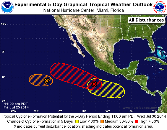
TROPICAL WEATHER OUTLOOK
NWS NATIONAL HURRICANE CENTER MIAMI FL
1100 AM PDT FRI JUL 25 2014

For the eastern North Pacific...east of 140 degrees west longitude:

The National Hurricane Center is issuing advisories on Tropical
Storm Genevieve, located more than a thousand miles east-southeast
of Hilo, Hawaii.

1. Shower activity associated with an area of low pressure centered
about 1150 miles southwest of the southern tip of the Baja
California peninsula has become better organized and the potential
for tropical cyclone formation during the next 24 hours or so has
increased. However, after that time, upper-level winds are forecast
to become less favorable for development as the system moves
westward.
* Formation chance through 48 hours...medium...50 percent.
* Formation chance through 5 days...medium...50 percent.

2. Showers and thunderstorms have also become better organized in
association with the tropical wave moving westward well south of the
coast of southwestern Mexico. Upper-level winds are becoming
a little more favorable for development of this system and a
tropical depression could form during the next couple of days while
it moves west-northwestward at 10 to 15 mph.
* Formation chance through 48 hours...medium...50 percent.
* Formation chance through 5 days...high...60 percent.

3. Another area of low pressure is forecast to form well south of
southeastern Mexico late this weekend.  Some gradual development of
this system is possible after that time.
* Formation chance through 48 hours...low...near 0 percent.
* Formation chance through 5 days...low...20 percent.

Public Advisories on Genevieve are issued under WMO header
WTPZ32 KNHC and under AWIPS header MIATCPEP2. Forecast/Advisories
are issued under WMO header WTPZ22 KNHC and under AWIPS
header MIATCMEP2.

Forecaster Avila
List of Atlantic Outlooks (May 2023 - present)
List of East Pacific Outlooks (May 2023 - present)
List of Central Pacific Outlooks (May 2023 - present)
List of Atlantic Outlooks (July 2014 - April 2023)
List of East Pacific Outlooks (July 2014 - April 2023)
List of Central Pacific Outlooks (June 2019 - April 2023)
List of Atlantic Outlooks (June 2009 - June 2014)
List of East Pacific Outlooks (June 2009 - June 2014)